 As climate change increases the risk of wildfires across the globe, the spate of fires that hit Canada in May and June suggest that 2023 is on course to be the country’s worst fire season to date. These fires not only pose a serious threat to human life, wildlife the environment and property, they also affect air quality.
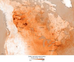
Using data from the Copernicus Sentinel-5P mission, the image shows the average concentration of carbon monoxide for May 1, 2023, to June 13, 2023. The extremely high concentrations, which are depicted in deep tones of orange, can be linked to active fires during the time. The image also shows how this air pollutant was carried as far as New York and over the Atlantic.
Image Credit: Contains modified Copernicus Sentinel data (2023), processed by ESA
