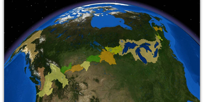
 It is a truism that Canada and the United States share the longest undefended border in the world. What is often overlooked in the observation, though, is that much of the border is water. More than 300 lakes and innumerable streams and rivers are part of or cross the international boundary, accounting for 40 percent of the 8,000-km (5,500 mi) long border. These lakes, rivers and streams are part of 15 distinct transboundary basins – from Alaska-Yukon border, to Coastal Mountain watersheds of British Columbia and Washington, stretching unbroken across the entire continent to the Great Lakes and St. Lawrence River and beyond to the coastal inlets of the Canadian Maritimes and New England.
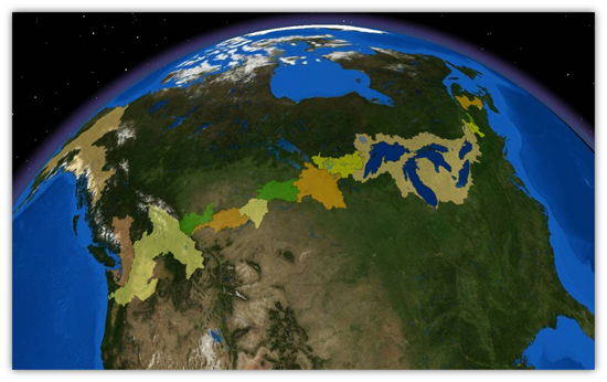
It is a truism that Canada and the United States share the longest undefended border in the world. What is often overlooked in the observation, though, is that much of the border is water. More than 300 lakes and innumerable streams and rivers are part of or cross the international boundary, accounting for 40 percent of the 8,000-km (5,500 mi) long border. These lakes, rivers and streams are part of 15 distinct transboundary basins – from Alaska-Yukon border, to Coastal Mountain watersheds of British Columbia and Washington, stretching unbroken across the entire continent to the Great Lakes and St. Lawrence River and beyond to the coastal inlets of the Canadian Maritimes and New England.
More than 100 years ago, the prospect of competing and conflicting uses of two rivers along their border brought home to both countries the need to cooperate on how the water resources they share are managed. For what happens on one side, in terms of use, or diversion or pollution or cleanup, will affect the other. This recognition, in turn, led directly to the establishment of the International Joint Commission (IJC) in 1909 and a century of cooperative management of a shared resource that is unequalled in scale or goodwill anywhere in the world.
Understanding these transboundary water resources has never mattered more, from environmental, economic and social perspectives. How the two countries manage their transboundary basins affects the lives and livelihoods of the people who live and work in these basins. Important ecosystems and the wildlife habitat they support depend on the waters of these basins. Major industries – shipping, hydroelectric generation, fishing, forestry, agriculture and tourism – depend on the health of these water resources, and on the level and predictability of their flows. For many Native Americans and Aboriginal peoples, the transboundary waters remain important sources of food and cultural identity.
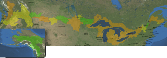
This map illustrates the topographically-based Basins that span the border between the United States and Canada.
An Absence of Seamless Data
Over the years, each country had developed its own suite of hydrographic datasets, using slightly different standards and interpretive rationales. Until recently, basin-level datasets that were at a scale usable to planners and managers stopped at the border, preventing the seamless exchange of hydrographic data and associated study results. This lack of seamless and scalable hydrographic data has also hindered the determination of a discrete area that could be considered a transboundary area of influence. There were existing national datasets for each country that pertained to how watersheds and hydrography were viewed up to the geopolitical border, but there needed to be a way to align agencies on each side of the border to have a seamless interpretation of the water flow and characteristics between the United States and Canada.
Since 1997, the IJC has progressed towards a 21st-century, watershed-based and local participatory approach under the International Watersheds Initiative (IWI). Given the resulting need for basin-wide datasets, IWI has supported work to produce consistent and comparable hydrographic datasets for drainage basins that straddle the Canada–United States border. In 2008, the IJC convened the Transboundary Hydrographic Data Harmonization Task Force to develop a binational, coordinated approach to the harmonization and long-term stewardship of hydrographic datasets covering binational drainage areas along the International Boundary.
The Conceptual Approach to Data Harmonization
Comprised of representatives from Environment Canada, Agriculture and Agri-Food Canada, U.S. Geological Survey, Natural Resources Canada and the U.S. Environmental Protection Agency, the task force set out to address the lack of seamless transboundary hydrographic data. It identified interpretive and programmatic disconnects in two fundamental geospatial hydrographic datasets: scalable- topographically hierarchical hydrologic accounting units (HUCs) and an analytic-scale hydrographic layer. From the Canadian federal perspective, these fundamental hydrographic datasets translate to Canada’s National Hydrographic Network (NHN) and the working version of Canada’s Fundamental Drainage Areas (FDA). From the U.S. perspective, the alignment will include the U.S. National Hydrographic Dataset (NHD) and the National Watershed Boundary Dataset (WBD) that, when harmonized, would create a shared geospatial foundation within which local, regional, and federal agencies can share, analyze, and archive data seamlessly across the boundary. The task force has implemented GIS software from ESRI as its common language to negotiate, coordinate and, document data interpretations.
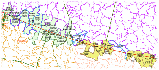
This figure illustrates the complex technical and collaborative coordination required to align Subbbasin (US8-CAN4) boundaries along the Canadian –U.S. boundary.
Resource agencies at the national and local levels were always looking at two, sometimes four different interpretations of what was happening on the transboundary landscape. The metrics or the scale was different, and even though both the United States and Canada are strong partners, it is surprising that the syntax, perceptions, and verbiage have been more of a divide than the actual boundary. The word ‘basin’ in North Dakota does not mean the same thing in Manitoba; this disconnect in the way hydrography is described and quantified is apparent along the entire boundary. By using GIS, we were able to reduce our language and streamline the manner in which we communicate and collaborate down to its essence, identify and quantify our differences, and come up with solutions that are all in a common geospatial context.
Coordination is moving forward on two fronts–hydrography and drainage areas–that are closely related but involve distinct data formats and expertise. Hydrography refers to the digital representation of streams, rivers, lakes, and other water features (the NHN and NHD). Drainage areas indicate contiguous, topographically defined areas where surface waters collect and form areas (FDA and WBD). The task force set up binational technical groups for hydrography and drainage areas to make sure that the two countries’ respective national datasets match more precisely within their shared drainage basins.
The Technical Approach
To accomplish this goal, first the NHN and NHD are compared along a 328-foot (100-meter) strip on each side of the border. Then any water features that do not align are connected and re-digitized following agreed upon guidelines. The newly delineated hydrographic features are sent back to the responsible agencies in each country for verification and inclusion into the national data structures. Harmonizing the data swap using the same guidelines for each drainage area enables the provincial, state, and federal systems to easily ingest the data. GIS technology helps to create truly sustainable, scalable, interoperable, and seamless hydrographic datasets along the Canada–United States border. ArcGIS and its range of extensions, including Arc Hydro, are used to match up international disparate data and facilitate discussions of drainage areas.
The drainage area harmonization team, which met in Regina, Saskatchewan, in February 2009, agreed on an analogous process for reconciling major drainage areas and the subsequent watersheds and subwatersheds that are shared by both nations. In this work, scale is an issue. The group determined that it would be more meaningful to focus on the meso-scale, i.e. 1:24,000-1:50,000 delineations, then shift to smaller delineations after the container has been established.
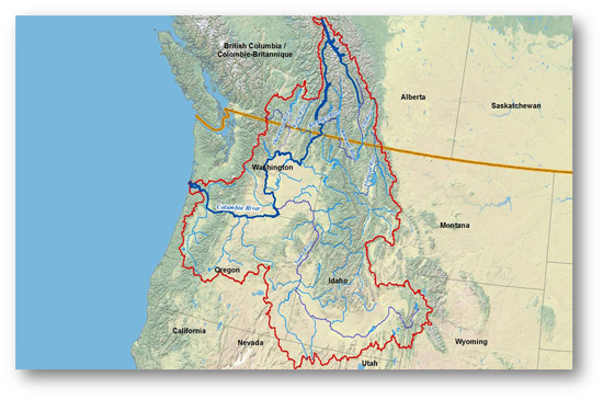
The Columbia River basin provides a good example of the cross-border nature and extent of Canada/United States watersheds.
The relevant meso-scale containers in the U.S. Watershed Boundary Dataset (WBD) possess eight-digit identification codes, and those in Canada’s Fundamental Drainage Areas (FDA) possess four-digit identification codes. The area slated for the hydrographic harmonization is hence referred to as the US8-CAN4 Swath. The harmonization team also made a preliminary assessment of the data swath, identifying areas of congruence and areas with substantial interpretive disconnects. The group agreed on protocols for merging the meso-level drainage areas within the swath and a process for reporting the harmonized areas back to each country, so that the respective Canadian and U.S. agencies can update their national datasets. After the individual US8-CAN4 drainage areas are reconciled, they are sent to the NHN-NHD group where the harmonization of the hydrography can resume.
A Phased Approach to Complete Hydrographic Harmonization
Harmonization of the drainage areas and hydrography is proceeding in phases. After the US8-CAN4 areas are reconciled and the hydrographic features within them harmonized, more detailed work further refines the drainage areas into higher-resolution, topographically-based drainage area accounting units. Participation of provincial, state, and local partners is important in this subsequent phase. Through the IWI, the IJC conducts regional and local delineation workshops where local agencies can contribute local expertise and knowledge to generate these high level (smaller area) watershed and sub-watershed delineations.
What’s special about this is the level of collaboration that has taken place between Canada and the United States, and GIS technology used as a common language is enabling us to work between the federal systems as well as between the states and the provinces.
Phase 1 of the binational hydrographic harmonization effort consists of the rectification of the US8-CAN4 drainage areas, which are then used as the working units for a first pass connection of flow between the NHN and NHD. One of the products produced from Phase 1 is a hydrographically defined area of transboundary influence, the geometry and the interpretation of which is recognized and incorporated into Canadian and U.S. resource agency data holdings. This fundamental hydrographic footprint along our shared boundary is the first step towards a seamless exchange of data, ideas, results and forecasts.
Phase 2 of the harmonization process– the refinement and inclusion of higher resolution drainage areas and the further harmonization of the streams, rivers, and water bodies — requires more strategic coordination with provincial, state, and local agencies. During this phase, the IJC-supported Task Force will organize local and regional workshops where local expertise will be used to determine the delineations. The targeted completion date for Phase 2 is the end of 2012.
The effort will be implementing ArcServer technologies to provide an interactive tool for the project’s stakeholders so that they can keep up to date with its progress. The IJC, in cooperation with task force members, will be launching an interactive Web-based hydrographic data harmonization tracking system. This system will enable the public to view monthly updates of the binational data harmonization effort and provide a forum through which regional and local partners can participate in the process.
The Rationale for Binational Data Harmonization
The ultimate goal of this process is to provide water resource managers and planners at the local, regional, and national levels with datasets and mapping tools at useful and truly integrated scales without the fault-line of the geopolitical border. The data used to inform the public, the governments, and resource specialists needs to be seamless to support communication and avoid redundancies and interpretive confusion. Using common datasets will help in providing more comparable hydraulic and hydrological modeling results and reduce the potential disagreements of study findings. This fully linked and harmonized hydrographic network, and cascading drainage areas encourages the use of existing automated tools that will provide more accurate and sustainable statistics to apply to an array of relevant water resource issues.
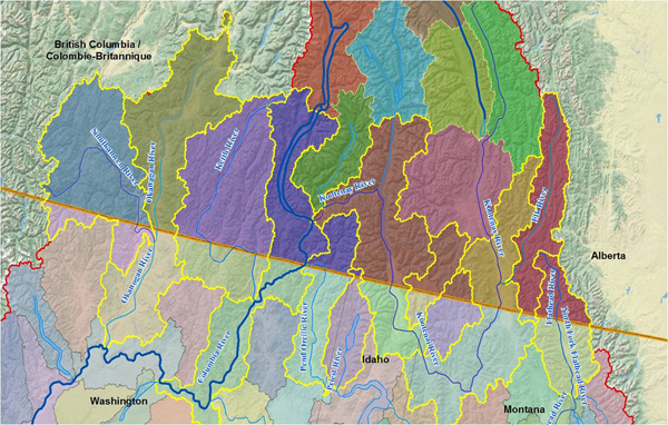
A closer view of the Columbia River Drainage Basin with the now harmonized Subbasins highlighted in yellow. The IJC will work with local and regional agencies to populate these Subbasin (US8-CAN4) areas with more refined watersheds and subwatershed areas.
Harmonizing data and encouraging a sustainable binational stewardship system for shared data is the first logical step in what will perhaps, in time, develop into a truly seamless, scalable and interoperable North American spatial data infrastructure. As a binational treaty organization with a century of cooperation on transboundary issues, the International Joint Commission is uniquely positioned to lead the effort to harmonize hydrographic datasets along the U.S.-Canada border. With local participation and a watershed-based approach having become the new paradigm for cross-border cooperation on water issues, reliable, integrated transboundary datasets will become increasingly indispensable to the IJC’s work.