Sensors and Systems
Breaking News
ICEYE and Esri Australia (through Boustead Geospatial) partner to deliver unprecedented hazard intelligence across Australia and Southeast Asia
Rating12345Partnership brings real-time hazard intelligence to emergency responders, utility and...
ESA and GEOSAT Join Forces to Accelerate Space Entrepreneurship and Sustainable Innovation
Rating12345 The European Space Agency (ESA) has signed a...
ABAX Launches ABAX Site Operations – Redefining the Real-Time Location System (RTLS) Market
Rating12345 ABAX, one of Europe’s providers of connected mobility...
  • Aug 13, 2025
  • Comments Off on Autonomous Breakthrough without GNSS or Fixed Infrastructure for Extreme Environments 
  • Featured, Top Stories
  • 4285 Views
  • Rating12345

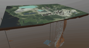
A 3D digital twin of the Pyhäsalmi Mine in Pyhäjärvi, Finland. (Credit: Callio Pyhajarvi)

Advanced Navigation successfully demonstrated a breakthrough in underground navigation, delivering high-precision positioning without reliance on fixed infrastructure or GNSS, in Europe’s deepest underground mine in Pyhäjärvi, Finland. 

The Hybrid Navigation System, combining a Laser Velocity Sensor with the Boreas D90 fiber-optic gyroscope Inertial Navigation System, achieved consistent sub-0.1 percent navigation error across multiple runs, without relying on any fixed positioning infrastructure, pre-existing maps or external aiding.