 In 2010, an innovative technology began assisting with the assessment of existing forest conditions as well as establishing a viable approach to long-term monitoring to support the management of natural forests in Indonesia. With the ability to rapidly collect highly accurate three-dimensional information of the forest from aircraft flying at three-quarters of a kilometer above the tree tops and traveling at nearly 200 km per hour, the laser technology known as LiDAR is likely to make a significant impact in overcoming the challenges faced by government agencies, commercial forest managers, and non-governmental organizations (NGOs) as they move to support reducing emissions from deforestation and degradation, or REDD+ initiatives.
In 2010, an innovative technology began assisting with the assessment of existing forest conditions as well as establishing a viable approach to long-term monitoring to support the management of natural forests in Indonesia. With the ability to rapidly collect highly accurate three-dimensional information of the forest from aircraft flying three-quarters of a kilometer above the tree tops and traveling at nearly 200 km per hour, the laser technology known as LiDAR is likely to make a significant impact in overcoming the challenges faced by government agencies, commercial forest managers, and non-governmental organizations (NGOs) as they move to support reducing emissions from deforestation and degradation, or REDD+ initiatives.
An Overview of the State of Forestry in Indonesia
Indonesia accounts for more than 40% of Southeast Asia’s total forests lands. The country was still densely forested as recently as 1950, but 40% of the forests that existed in 1950 were cleared in the following 50 years (according to Global Forest Watch).
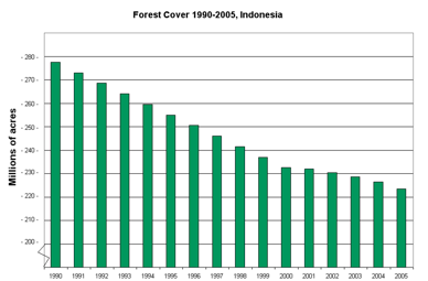
Change in forest cover in Indonesia 1990-2005. Source: World Resources Institute / South Dakota State / Indonesian Ministry of Forests
Over the past few years, Indonesia has been experimenting with the use of international funds designed to pay developing countries to curb deforestation, a primary cause of greenhouse gas emissions (GHG). The approach, known as Reducing Emissions from Deforestation and Forest Degradation in Developing Countries (REDD or REDD+ if improved or sustainable forest management is included), is widely seen as one of the rare global environmental successes as Indonesia has seen its rate of forest loss drop from 1.7 percent per year in the 1990s to 0.7 percent over the last five years. However, to be successful with REDD and the emerging carbon credit market, accurate monitoring techniques will be required. This means that realistic, objective, and transparent approaches must be developed to accurately measure the makeup of the forest (i.e. which species are present, state of growth/maturity, etc) as well as provide for the ability to monitor and quantify any changes that happen to the forest over time.
Introduction to Airborne LiDAR Technology
LiDAR is an acronym for “light detection and ranging”, similar to the more familiar term “radar” (for “radio detection and ranging”). Distance or range measurements are made by sending a pulse of laser light out from the LiDAR sensor, then recording the return pulse(s) and converting round trip time to distance based on the speed of light.
Measurements are made in 3 dimensions (X, Y, and Z), and when operated on an airborne platform such as a fixed wing airplane or helicopter with the LiDAR system viewing down, the system can map terrain, land cover, and structures (vegetation, buildings, power lines, etc.) with accuracies measured in centimeters.

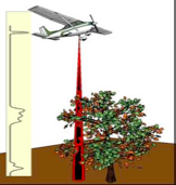
LiDAR measures distance by sending pulses of laser light that strike and reflect from the surfaces of the earth.
Current systems acquire more than 100,000 pulses per second, enabling them to cover more than 10,000 hectares in a typical day. The resulting resolution and accuracy are similar to aerial photography (and much higher resolution than satellite data), resulting in more complete and accurate measurements.
The additional advantage of LiDAR is that all measurements are made in three dimensions. And even though the laser pulses cannot penetrate vegetation, some of the laser energy can often find a way through small gaps in the forest canopy to reach the ground. Each outgoing laser pulse spreads out as it moves towards the ground, and will typically generate more than one “return” pulse – such as from the top of a tree canopy, branches and understory, as well as the ground.
The results of an airborne LiDAR survey are a highly detailed terrain map (“bald earth” with all vegetation and buildings removed), plus other valuable information including canopy height, canopy closure or gaps, hydrological flow, and slope maps. This type of detail is typically not resolvable in satellite data, and enables applications that require accurate monitoring of forest stand structure and health. One additional consideration for applications requiring forest monitoring is that the high resolution and accuracy of LiDAR data enables traceable and reproducible measurements, which is invaluable for any application that requires repeated monitoring with regard to change over time, such as MRV (Measuring, Reporting and Verification).

This is a forest profile return from LiDAR.
The benefits of utilizing airborne LiDAR surveys for Indonesian forestry applications are many, and include the ability to quickly create accurate three-dimensional maps of remote forests without the often challenging and costly aspect of sending field personnel to complete ground surveys requiring days or weeks to cover the same area. Furthermore, the LiDAR surveys are proven to be highly accurate, and avoid many of the challenges that can occur with ground surveys.
Applications – Production and Preservation
Interestingly enough, international REDD initiatives are not the only force currently impacting the Indonesian forestry community. The Tropical Forest Foundation (TFF), an international, non-profit, educational NGO dedicated to the conservation of tropical forests through sustainable forestry, has become widely recognized for establishing demonstration models and training courses to show the advantages and teach the principles of sustainable forest management. TFF’s regional programs have become synonymous with the promotion and training of Reduced Impact Logging (RIL), a program that consists of technologies and practices that are designed to minimize environmental impacts associated with industrial timber harvesting operations.
As stated in the document describing the TFF Standard for Reduced Impact Logging, “In recent decades, it has been recognized that proper planning of harvesting operations and application of appropriate technologies can considerably reduce the damage caused by conventional logging methods in tropical regions.”
Well-developed harvest plans include pre-harvest inventories, protection of hydrological functions, road, landing and skid trail planning, construction, maintenance and de-activation activities, as well as the recognition and protection of culturally and environmentally significant features. Together, these steps have a positive impact on the outcome of the overall operation.
In order to create a viable harvest plan, managers of forest concessions must have access to accurate information of the forest to be harvested. This is the reason the airborne LiDAR technology shows so much promise for RIL. With a single airborne LiDAR survey, the following deliverables can be produced:
RIL certified forestry operations also further Indonesia’s goal of reducing carbon emissions into the atmosphere, since it has been documented that decreasing the number of kilometers of roads, skid trails and the size of log decks positively impacts a project’s carbon output.
Case Study
In June of 2010, The Nature Conservancy (TNC), Forest-Carbon, and Credent Technology, worked together as a project team to develop a pilot demonstration project over a site in East Kalimantan, Indonesia, being monitored under the REDD forest carbon program. Working in partnership with Forest-Carbon, Credent acquired LiDAR data in a test region that would provide a good representation of the type of terrain and land cover found throughout the region. This LiDAR overflight is one of the first conducted in Indonesia specifically designed to quantify the ways in which the information generated from the airborne survey could be leveraged to assist the REDD project reach its stated goals. The data collection was acquired using an Optech 3100EA LiDAR system flying approximately 300 km/hour from an elevation of 700m above ground level (AGL). The data were collected with a single sortie and, to facilitate the future use of the data, the flight lines were delivered as 21 separate tiles, 2km * 2km in size.
From the raw data, Credent Technology produced the standard LiDAR survey deliverables of:
A Digital Terrain Model (DTM): Utilizing the laser pulses that penetrated the canopy and struck the ground, a “bare earth” terrain model was created
Digital Surface Model (DSM): This model represents the first item that the laser pulse reflected off of, which is generally the top of the forest canopy
However, in an attempt to improve the value and usefulness of the data collected, Credent has developed some additional value added processing of the LiDAR data and created the following mapping products, which were first shown at The Nature Conservancy’s REDD – Improved Forest Management (IMF) workshop, less than 30 days after the collection flight:
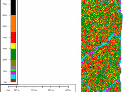
The Tree Canopy Closure Map portrays the size and location of gaps in forest canopy.
Preliminary Results and Benefits
Preliminary analysis of the Kalimantan data shows good information was obtained with the LiDAR data collection. In a fairly short period of time, Credent was able to produce not only the standard products delivered with all LiDAR acquisitions, but also to build the value-added data sets specifically useful to forest managers (see above).
Further analysis is currently underway by TNC and Forest Carbon to determine specific information that can be derived with regard to a REDD project site. In addition, information from eight ground plots covered by the LiDAR system was collected during October 2010 to use for additional validation of the LiDAR data.
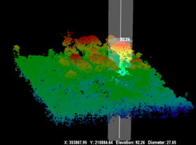
The Tree Height Map shows the elevation of the top of the tree canopy.
The Future Looks Bright
Initial research has demonstrated how LiDAR data can be valuable, efficient, and cost effective to establish a baseline measurement of the status of an existing forest. The tree canopy closure map documents the existing gaps in the forest canopy, which can be useful when monitoring a forest for changes over time in support of MRV and forest certification activities.
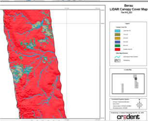
The LiDAR Canopy Cover Map shows the extend of forest canopy at a broader scale.
Moving forward, Credent Technology and its partners are continuing to invest in the research necessary to refine both the actual LiDAR collection process as well as the development of additional post processing methodologies and software that will provide forester managers with the types of information they require. Based on the encouraging results from the 2010 Kalimantan LiDAR collection, plans are being developed on how to improve the use of the LiDAR technology for tropical forest applications, including:
Much has been learned during the past year with regard to how an airborne LiDAR survey can assist with both REDD conservation efforts as well as supporting the management practices of forest concessionaires. During 2011, additional research will be conducted by Credent Technology and its partners to improve the quality of the information available from LiDAR as well as improve the level of automation involved. The ability to quickly and accurately map both the forest canopy and terrain in three dimensions provides new and exciting opportunities to forest managers in Indonesia.
About the other Author: Abhineet Jain is a LiDAR application specialitst at Credent Technology (Asia) Pte. Ltd.; e-mail: abhineet at credent-asia.com.
.