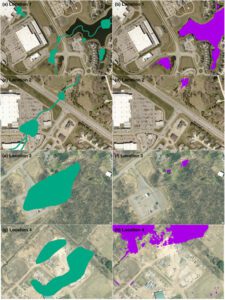
The model correctly omitted wetlands where they had been lost to development, despite these wetlands remaining in the outdated training data, as shown in this image (outdated training data shown in green; model prediction in purple, overlaid over recent satellite imagery). (Credit: Chesapeake Conservancy’s Conservation Innovation Center)
Chesapeake Conservancy’s data science team developed an artificial intelligence deep learning model for mapping wetlands, which resulted in 94% accuracy. Supported by EPRI, an independent, non-profit energy research and development institute; Lincoln Electric System; and the Grayce B. Kerr Fund, Inc., this method for wetland mapping could deliver important outcomes for protecting and conserving wetlands. The results are published in the peer-reviewed journal Science of the Total Environment.
The team trained a machine learning (convolutional neural network) model for high-resolution (1 meter) wetland mapping with freely available data from three areas: Mille Lacs County, Minn.; Kent County, Del.; and St. Lawrence County, N.Y. The full model, which requires local training data provided by state wetlands data and the National Wetlands Inventory (NWI), mapped wetlands with 94% accuracy.
