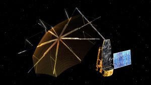
 Set to fly in 2022, ESA’s Biomass Earth Explorer satellite with its 12-meter diameter radar antenna will pierce through woodland canopies to perform a global survey of Earth’s forests—and see how they change over the course of Biomass’ five-year mission.
Trees are an integral, much-loved element of our environment; they also hold clues to our collective future. Knowing the amount of carbon bound up in forest biomass will sharpen our understanding of climate change and its likely effects on the global carbon cycle.
Biomass will achieve this using a ‘synthetic aperture radar’ to send down signals from orbit and record the resulting backscatter, building up maps of tree height and volume. To see through leafy treetop to the trees themselves, Biomass will employ long-wavelength ‘P-band’ radar, which has never previously flown in space. It will have its signals amplified to travel down from a 600-kilometer altitude orbit down to Earth and back.
ESA’s Directorate of Technology, Engineering and Quality worked with the Biomass mission team on the advanced signal amplifiers needed to make the mission feasible, based on the most promising semiconductor since silicon.
Image Credit: Airbus Defence and Space
