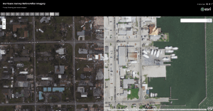
A screenshot shows GISCorps post-event imagery from Hurricane Harvey.
The impacts of Hurricane Harvey are being felt far and wide. As the rain continued to fall, and flood waters rose, an army of citizen-rescuers answered the call. And as governments encouraged citizens to help one another, the non-profit organization made up of mapping experts also answered the call. GISCorps, a program of the Urban and Regional Information Systems Association (URISA), has been providing a range of mapping and disaster-response services for more than 14 years worldwide.
GISCorps volunteers conduct most of their work remotely and nearly half of their work responding to disasters. These volunteers harness the power of the cloud-based ArcGIS Online platform for such tasks as data collection, data cleansing, and creating story maps and map galleries to communicate needs and impacts.
“GISCorps volunteers have been involved in almost every disaster since 2003,” says Shoreh Elhami, the founder of URISA’s GISCorps. “We have worked on Hurricane Katrina, the Asian tsunami, the cyclone in Burma, the Ebola epidemic, and many more.”
Applying to become a GISCorps volunteer can only be done online.
