 Over the past decade, green building has gone from the fringe to the mainstream of the building industry. In many communities, buildings have “gone green” by adopting strategies such as integrative design, energy modeling, commissioning, enhanced energy efficiency, renewable materials, attention to daylight and views, water conservation measures, and on-site renewable energy generation. Use of these green building strategies in new and existing buildings can dramatically reduce energy consumption, greenhouse gas emissions, and water use while creating more comfortable and satisfying indoor environments. The green building movement seeks to sustain and accelerate these trends with the goal of driving permanent shifts in practices to benefit people and the environment.
Over the past decade, green building has gone from the fringe to the mainstream of the building industry. In many communities, buildings have “gone green” by adopting strategies such as integrative design, energy modeling, commissioning, enhanced energy efficiency, renewable materials, attention to daylight and views, water conservation measures, and on-site renewable energy generation. Use of these green building strategies in new and existing buildings can dramatically reduce energy consumption, greenhouse gas emissions, and water use while creating more comfortable and satisfying indoor environments. The green building movement seeks to sustain and accelerate these trends with the goal of driving permanent shifts in practices to benefit people and the environment.
The U.S. Green Building Council (USGBC), located in Washington, D.C., helps advance this vision with its Leadership in Energy and Environmental Design (LEED™) series of rating systems. The U.S. Green Building Council is a 501(c)3 not-for-profit organization. LEED helps identify and prioritize best practices related to location and planning, sustainable sites, energy and atmosphere, water efficiency, materials and resources, and innovation in design. Ten years ago, the initial release of LEED 1.0 focused on commercial new construction. Today, LEED 2009 encompasses a family of systems that reach across the life cycle of built environments including neighborhoods, commercial buildings, health care facilities, schools, and homes. LEED provides a consensus-based national standard for green building practices linked to rigorous third-party review and certification.
A Portal to Green Projects
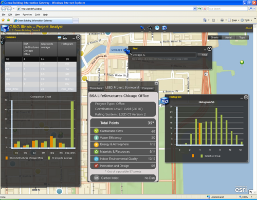
Helping anyone who is interested explore and navigate green buildings is the Green Building Information Gateway (GBIG), located at gbig.org. The portal is built with Esri ArcGIS Server and the ArcGIS API for Flex and hosted by Amazon Web Services; it is being made available in phases for large metropolitan statistical areas (MSAs) across the United States. The first available MSA is focused on Chicago, Illinois, followed by Washington, D.C. GBIG’s web-based, map-centric portal combines a mobile application and web-based analytic environment.
GBIG’s web-based, map-centric portal combines a mobile application and web-based analytic environment.
GBIG provides an unprecedented ability to explore, navigate, and compare green buildings over both space and time. Using tools within ArcGIS, projects can be animated to depict their growth over time. This illustrates the dynamic landscape of green building practices while providing valuable context for the next generation of high-performance projects.
GBIG users can find LEED-certified buildings (buildings that have been formally recognized as using environmentally friendly building practices) using a combination of text-based searches of project attributes and geographic searches for addresses, such as searching by proximity or travel time. These capabilities allow green building practitioners to quickly identify practices and performance metrics for similar projects in a specified area. Over the next year, these spatial and attribute-based searches will be expanded to include information about associated LEED accredited professionals, USGBC member organizations, operational project performance metrics, educational materials, and products and services. Developing GBIG with ArcGIS Server technology provides the interoperability needed to connect to third-party data sources and understand green building attributes in the context of data such as occupancy rates, rents, or demographic forecasts.
“We hope that by providing a means for people to systematically search green building projects, they are inspired to build better and exceed the current level of prevailing practice,” says Dr. Chris Pyke, vice president of research, USGBC.
GBIG provides an unprecedented ability to explore, navigate, and compare green buildings over both space and time.
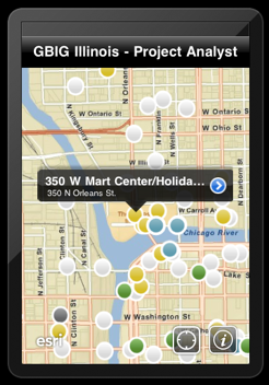
A mobile application provides the potential to explore green building in the field by locating green building activities close to users. Built on Esri Business Analyst, the GBIG mobile application is free and available for Apple’s operating system for iPad, iPhone, or iPod touch. Users can see their location and information about nearby LEED-certified projects. These projects, shown as point locations on the map, can include neighborhoods; new construction; and offices, retail facilities, schools, and other public buildings. Project attributes indicate levels of performance with respect to categories of green building strategies or specific issues, such as the new LEED 2009 Carbon Index.
This is useful for practitioners interested in understanding green building practices and project performance in an area. “It’s difficult to know what is happening around you today because market conditions are changing quickly, and we have no systematic way of seeing what projects have achieved in a given area,” says Pyke. “This application allows green building practitioners to find information on nearby projects, providing transparency and disclosure—core missions for our organization.”
Making LEED Certification Regional with GIS
LEED 2009 represents USGBC’s state-of-the-art family of rating systems. LEED 2009 consists of a combination of mandatory prerequisites and elective credits. Projects must satisfy all prerequisites and a certain number of credits to achieve certification. The number of points allocated to each LEED credit reflects its relative value for reducing a set of 13 environmental impacts developed by the U.S. Environmental Protection Agency. These categories include greenhouse gas emissions, fossil fuel use, and water consumption.
LEED 2009 uses an analytic framework that estimates building-related impacts and applies this information to allocate points to each credit in the rating system. Credits that address the most important impacts receive the greatest number of points. Today, USGBC refines national benchmarks with a ZIP Code-based approach that customizes LEED 2009 rating system requirements for different regions. USGBC is exploring GIS-based solutions that help create, identify, and prioritize green building strategies for local conditions and regional priorities.
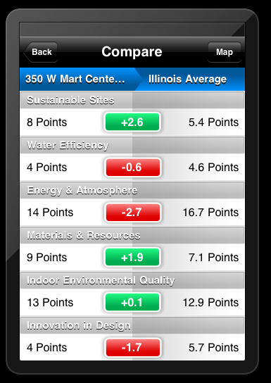
GBIG provides the ability to compare metrics of individual buildings against the state average.
For example, GIS-based approaches will help refine ZIP Code-level analyses to facilitate consideration of geographic variation in population density, regional electricity generation mix, availability of public transportation, and water supply characteristics. Combinations of these factors vary significantly between regions; between neighborhoods within a city; and, in some cases, from block to block.
Understanding Market Patterns and Trends
ArcGIS and Business Analyst help USGBC members understand spatial patterns in green building certification, first by sharing spatial data on LEED-certified and -registered projects through ArcGIS.com. “We see this as providing a platform for analyzing market conditions and making decisions toward most effectively meeting the demand for green real estate at a specific location,” says Pyke.
Real estate professionals can overlay LEED project data on other sources of supply-and-demand indicators to determine the size and character of the market for sustainable space. These types of analyses offer the potential to map a wide variety of relationships to understand current patterns and create market forecasts and scenarios.
ArcGIS and Business Analyst help USGBC members understand spatial patterns in green building certification.
“GIS is rapidly becoming part of the future of green building,” says Pyke. Green building practitioners are beginning to recognize the need to move information technologies to the front of the sustainable design process. A spatially aware, analytically driven green building practice will include clear processes to define performance metrics across the life cycle of built environments; application of fundamental geodesign principles, which combines planning built and natural environments in an integrated process; and advanced technologies to monitor performance over time.
“The result will be higher-performance, more sustainable built environments that are informed by place and context, engineered to maximize benefits for people and the environment, and operated to achieve continuous improvement,” Pyke explains. “GIS will contribute to this process by leveraging and extending its traditional strengths as a platform for data integration, interoperability, quantitative analysis, and visual communication.”
Karen Richardson is a writer with ESRI, e-mail: krichardson at esri.com
Resources
For more information on green applications for facilities maintenance using GIS, visit esri.com/fm.
