 Much has been written about the product adoption cycles of new technologies, such as the automobile, and more recently the cell phone, the Internet, and broadband. The book “The Next Great Bubble Boom” by Harry S. Dent, Jr. uses standard “S-Curve” diagrams to map the status of a certain technologies. This article extrapolates Mr. Dent’s schema to map the status of GIS technologies while attempting to assess investment risks and benefits.
Much has been written about the adoption of new technologies, such as the automobile, and more recently the cell phone, the Internet, and broadband. Recommended reading on this topic is the book “The Next Great Bubble Boom” by Harry S. Dent, Jr. Most of the market analysis data for this column were extracted from that book.
Mr. Dent presents a standard “S-Curve” that is being used in economic circles in attempts to map the status of a certain technologies while attempting to assess investment risks and benefits. He identifies this curve as “Four-Stage Industry S-Curve Cycle” and draws it as shown in Figure 1. This article extrapolates Dent’s schema in an attempt to apply this analysis to GIS.
Mr. Dent presents a standard “S-Curve” that is being used in economic circles in attempts to map the status of a certain technologies while attempting to assess investment risks and benefits. He identifies this curve as “Four-Stage Industry S-Curve Cycle” and draws it as shown in Figure 1.
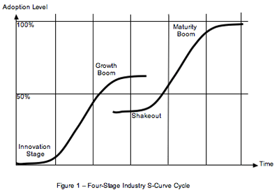
This curve assumes an initial “Innovation Stage”, in which technologies are launched. This is followed by a “Growth Boom” that is used to build a market with many competitors. This boom reaches a peak. After this peak, the industry goes through a “Shakeout” in which many players, including investors, leave that market. This shakeout apparently occurs right around the half-way mark between industry launch and maturation. This is followed by a new “Maturity Boom”, which also peaks (close to 100% adoption).
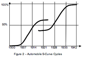
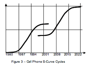
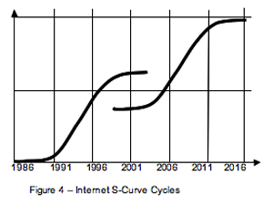
Mr. Dent’s book presents some examples for this curve, as applied to the automobile, the cell phone, the Internet, and broadband, as shown below.
 |
 |
 |
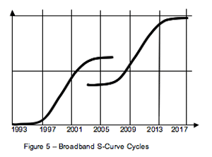 |
According to these curves, technology adoption can be split into rough time elements that control the cycles. Automobile adoption was roughly split into seven-year cycles, as was cell phone technology. The internet seems to follow five-year units, and Broadband four-year units. The short cycle of the cell phone is due to the fact that that technology was successfully launched long before a satisfactory infrastructure was available.
The length of these units apparently depends on the following two pre-conditions:
• The level of investment in the technology
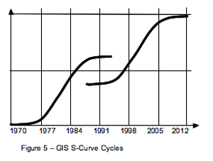
Figure 6 also indicates that GIS is well underway in its “democratization” cycle. How can that be? Well, if one considers the following alternate forms of GIS, one would have to agree:
All the above are efforts to democratize GIS, and all are mature technologies already. At the same time, these technologies became democratized simply because the cost was reduced to non-budget levels (no need to include them in budgets, since they became free or petty cash solutions). Publications are just now starting to catch up on the topic, almost after the fact.
The idea of a seven-year cycle is reinforced by the fact that the effort by the U.S. Census to shortcut this cycle, even with a considerable investment, is not advancing well.
As other technologies have taught, the following statements can be made:
It is also clear that the greatest investment in data is occurring in democratized forms of GIS. In that sense, community databases (as in County Assessor Maps) are finding their way into vehicle navigation solutions, and at the same time they are being distributed from public-access web pages. As such, this GIS evolution is accompanied by major data democratization. This is proven by the fact that most data conversion companies are presently busy building databases that are directly or indirectly earmarked for public consumption, and the battle for data ownership has begun.
This also suggests that a vendor’s attempt to survive on the basis of paralyzed pre-shakedown software would most probably be unsustainable. If GIS vendors don’t complement hard-to-implement solutions with easy-to-use interfaces, then others will. Also, modern solutions have to start including democratized forms of GIS, as in a marriage of outside plant management and vehicle navigation. The pressure is on. At present, the only hope for any GIS vendor is to bring democratizing products to market.
What Are the Next Steps in Democratization?
One of the obvious next steps for democratizing GIS is the extreme simplification of data access and edit front-ends for conventional GIS, so that they are as easy to use as a telephone, and that data access training would take less than 10 minutes total.
Another would be the establishment of a “standard” way of selling data. This would consist of every city, county, and state using one and the same delivery format, pricing structure, and identifiable delivery outlet for the distribution of data. This would also require a “standard” set of rules and regulations regarding the data.