 Management of major transport infrastructures such as highways is an extremely complex task that requires different teams handling a vast range of very heterogeneous static and real-time information. This challenge has been faced in the context of one of Italy’s most important motorways, through development of a scalable spatial data infrastructure that allows managing a wide range of Geographical Information (GI).
The system developed is heavily relying on open standard by OGC – Open Geospatial Consortium. However, unlike standard spatial data infrastructures (SDI), which will address relatively static data at fixed time intervals, the system developed required handling a very large range of dynamic data retrieved by sensors located along the highway path.
The main objective of the project was to create a user friendly system of systems, which could connect to existing software infrastructures and legacy networks, in order to deliver a comprehensive, coordinated and sustained solution, acting as a single point of access, to be used by motorway operators to improve the management the highway.
Management of Transport Infrastructure
Major transport infrastructures including railways, highways and motorways are of strategic importance. All major transportation networks are complex systems of systems requiring articulated inter-organisational and often cross-boundary integration. In fact the key strategic relevance of some of TEN-T requires a further level of cross-border interoperability.
At the EU 27 level trans-European transport network (TEN-T) include 5 million Km of roads, 215,000 Km of railway lines and 41,000 Km of navigable inland waterways. Road transport, in particular, is constantly increasing with a goods transport growth by 35% between 1995 and 2004 and with a further expected growth of +55% by 2020 if compared to figures recorded in 2000.
The project presented has been developed for the A22 Italian motorway, an important segment of the so-called corridor 1 (Palermo-Berlin), one of Europe’s most strategic communication links between north and south. The motorway stretches for a total length of 313 Km with a daily number of vehicles transiting between 30 and 55 thousand of which 25% is made of heavy vehicles. The A22 motorway has seen a constant traffic growth, in the last 20 years, bringing to a traffic increase of approximately 80% with regards to both light and heavy vehicles. It is estimated that every year, on average, 33 million tons of goods transit across the Brenner Pass, located at the end of the motorway marking the border between Italy and Austria.
Such an important communication route is managed through a complex system of system made of different IT infrastructures with limited interoperability among them. For this it is essential to be able to manage the wide range of information available, including static data on the network and their related infrastructures, as well as dynamic information such infrastructural sensors, real-time traffic data, localised weather data, plus all the documents necessary for the management and maintenance of all systems related to the infrastructures, which have an implicit geographical relation to the feature in the real world they refer to.
The main goal of the project was therefore to improve interoperability both at the intra- and extra- organisation level. Being able to deal with all the aforementioned information was considered essential to be able to ensure proper management and reduce costs, as well as to reduce risk of disruptions caused by poor quality of service. The latter in fact would be cause of very large scale disruptions and high social as well as economical costs, as closing down the motorway would cost on average 750,000 Euros/day only in terms of revenues lost.
Delivering a single point of entry
This outlook highlights the importance of being able to access this information from a single point of entry, to provide key value added to the operators responsible for planning, management and maintenance of the different sub-systems. For this reason the project has implemented an infrastructure designed to ensure close integration between the existing data repositories, both static and dynamic.
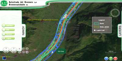
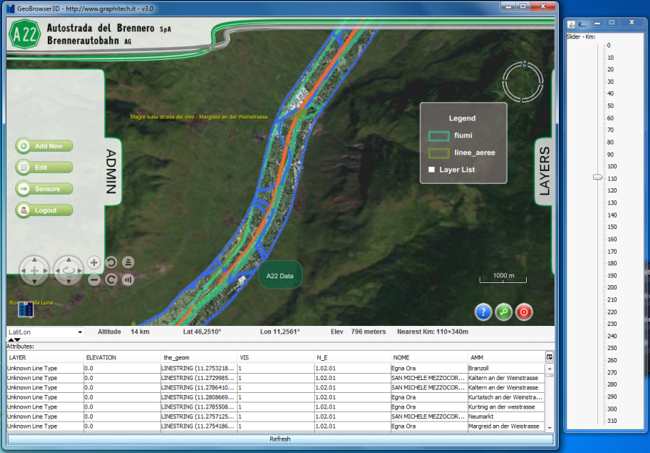
By using the system developed, an operator can access all the necessary information through a 3D interactive browser which can be used to define queries and access live information all within a unique graphical context. One of the main advantages of the entire infrastructure, which relies from the server standpoint, on a Service Oriented Architecture, is the support for a wide range of international standards both de jure and de facto allowing tight integration with existing repositories, compliancy with latest international directives –both at the EU and national level-, and interoperability with other systems.
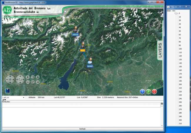
The operator starts the 3D client from a web link available through the enterprise intranet. This is deployed within a local server as cross-platform Java WebStart™ application. While the user navigates the 3D scene containing the whole motorway segment, a number of requests are sent to the servers which send back altimetry information, necessary to create the 3D scene of the territory, as well as different imaging or vector datasets which represent different logical layers.
The latter can be activated at wish by the operator and freely overlaid at runtime. From the server side this has been made possible through the development of an infrastructure developed as Service Oriented Architecture (SOA) whereby a number of software facilities are available within the intranet as web services.
These exchange information with other server components as well as with the client application through standardised protocols. This has been essential to ensure protocol-level interoperability with other enterprise software such as GIS applications. More specifically transmission of geographical information based on open standards from the Open Geospatial Consortium – OGC such as WMS (Web Mapping Server), WFS (Web Feature Server), and SLD (Style Layer Descriptor).
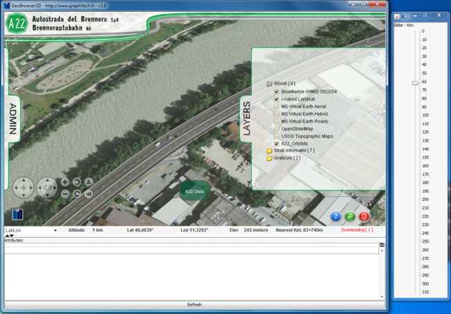
When the operator accesses the different data sets they can do through a table of content, structured as logical tree, containing different information layers. These can contain information of different nature. These may represent for instance different orthophotos (typically made resulting from satellite or airborne acquisition campaigns) or other raster maps (e.g. planning, etc.), available as Web Map Service (WMS). Layers can also be used to represent vector information, as Web Feature Service (WFS).
This is the case of vector-based datasets describing for instance the road network, associated infrastructures etc. Additionally layers can also refer to real-time information retrieved from sensors as well as documents present within the enterprise intranet portal, available via Microsoft SharePoint services, each related to a specific location along the motorway.
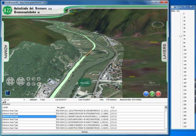
In fact it is worth noting that the very nature of the business activities, requires constant association of each piece of information to a position in space, specifically to a position along the motorway segment. In other words all documents, be this a report –available as pdf- on the maintenance state of a part of infrastructure, always refer to the corresponding position along the motorway route. This indirect geo-referencing, based on the concept of linear distance along the motorway path, has allowed creating a geocoding web-service capable to relate each piece of information, meant in the widest sense, to a precise location in the space, corresponding to the point along the motorway. All the information including both traditional GIS data (e.g. geographical features on the road network) as well as non-geographic data (e.g. a pdf) can be then stored within a geo-spatial database and be queried according to their position in space.
This way it becomes possible for the user to fly to a specific part of the motorway segment and to make a query on the available information related to that part of the motorway. The result of the query, made to the central database, is then returned back to the client that in turn shows the list of available resources as a formatted table as well as their localisation through an icon within the 3D scene.
The query can be formulated through a slider that implicitely filters the information related to a motorway segment of interest, based on the road kilometer index (e.g. from km=14 to km=34). The information available from the enterprise database, deployed as Microsoft SQL Server, is then extracted and sent back to the client via WFS. The result, which is both rendered within a table as well as elements within the 3D scene, can be further refined until the items of interest are found.
The operator can then select the specific resource of interest. If this is a geographical feature then it is shown directly within the 3D environment else, in case of other documents, the software associated with the relevant file format is automatically invoked. This way it becomes very convenient to access, from a signle point of access both traditional geographical information and other non-geographical data such as pictures, videos, reports, excel sheets, autocad technical drawings, Microsoft Office documents and the like.
Furthermore at the same way it is possible to access sensor data. As soon as the relevant resource is selected, the system sends a request to a web service which is responsible for managing the relevant dataset. The information is then rendered within a component, always placed within the same geographical context, and related to the position of the feature in the real world. The graphical component behaves as an HTML container where all sensor related information are displayed as pre-formatted by the relevant web-service. As a result the user can for instance select a given resource representing a video camera and see, in overlay, the live-images, together with additional information on the last available image, possibly information on the camera, all this localised in the correct position in space.
This approach is extremely scalable, as the management of the information related to a given resource, in this case a live sensor, is managed directly by a web-service, with the client providing only the graphical framework for rendering the formatted result in the correct position in space.
Similarly each different data type is dealt by different web-service each available through a potentially different server which could be physically located at different geographical locations. With regard to this the client is entirely content-agnostic, as it provides access to whatever information may be made available by a given web-service provided that the latter complies with the relevant OGC or W3C standard.
This approach has a number of advantages. The most important being its great scalability in that it becomes very easy to introduce new datasets, either through existing services or by deploying new ones. Performances issues can also addressed by simply scaling up accordingly the server infrastructures.
It is worth noting that the use of interoperable open standards from OGC (Open Geospatial Consortium) makes it possible for the operators to use other proprietary GIS application to access and manage spatial information made available to the operators. Similarly this approach guarantees that interoperability can be ensured when exchanging information with external departments or public administrations.
Conclusions
This paper presents the results of a project being developed for a major Italian motorway which allows integrated access to a wide range of static as well as real-time information from within a single point of access. All information including geographical and non-geographical information (e.g. documents) are made available according to the location of the real object or infrastructure they refer to in the real world. This way it becomes extremely convenient for the operator to access, in an interactive manner, a variety of information available for a given segment of the motorway by simply flying towards it and filtering the information required according to logical layers as well as by their position along the motorway path. Once the relevant piece of information is found, through its representation in the 3D scene or through a formatted table which is returning results of the spatial queries, this can be directly accessed from within the client application. The entire framework has been engineered with scalability in mind as well as to ensure highest level of interoperability. To do so the design of the infrastructure has been based on a Service Oriented Architecture while the communication between client and server, as well as among different server components, is ensured through open, internationally acknowledged standards.
Acknowledgments.
Parts of the achievements discussed in this paper as well as the data shown in the images are the result of a project commissioned by Autostrada del Brennero SpA. Some of the achievements presented have also been co-financed by the i-Tour project co-funded by the European Community Programme FP7 (grant agreement SCP8-GA-2009-234239) and NatureSDIPlus project co-funded by the Community Programme eContentplus (grant agreement ECP-2007-GEO-317007).
—————————————————————————–
Raffaele de Amicis, Giuseppe Conti, Stefano Piffer, Federico Prandi, Marco Calderan
Fondazione Graphitech,
Via alla Cascata, 56/C
38121 Trento – Italy
http://www.graphitech.it/
