Wednesday, May 29th, 2013
Blue Marble Geographics is pleased to announce the release of Global Energy Mapper version 14.2. The latest release of this powerful GIS software for energy professionals offers many new and improved features and functions. Some of the major improvements include a new pile volume calculator in the Digitizer Tool, further improvements to the Pad Site
Wednesday, May 29th, 2013
OpenGeo, the world’s leading commercial open source geospatial company, took geospatial deployment analytics to new heights on Friday with the public launch of Mapmeter beta, its groundbreaking server analytics console, while at FOSS4G-North America 2013.
Wednesday, May 22nd, 2013
OpenGeo, the world’s leading commercial open source geospatial company, is excited to announce a full public beta of its new server analytics console while at FOSS4G-North America 2013. The product, formerly known as “The Enterprise Console,” is now Mapmeter, a full administration and management tool for analyzing GeoServer systems.
Wednesday, May 22nd, 2013
Blue Marble Geographics is pleased to announce the release of Global Mapper version 14.2. This update to the company’s popular desktop GIS software offers many new and improved features and functions. Some of the major improvements include several scripting updates, improved Volume Measurement tools, new right-click option to the vector data Search dialog, many LiDAR
Tuesday, May 21st, 2013
Avenza Systems Inc., producers of MAPublisher cartographic software for Adobe Illustrator and the popular PDF Maps mobile app, is pleased to announce the release of Geographic Imager 4.2 for Adobe Photoshop. New formats are supported, including writing to the DEM TIFF format which saves raw DEM values and exporting web tiles to Google Maps or
Friday, May 3rd, 2013
Blue Marble Geographics, in partnership with the University of Southern Maine, is pleased to announce the release of COAST v1.0. COAST is a free software tool built on the Global Mapper SDK for use in modeling storm surge and sea level rise in relation to adaptation strategies and the cost-benefit analysis of those strategies. Blue
Tuesday, April 23rd, 2013
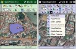
Supergeo Technologies, the leading global provider of complete GIS software and solutions, launches SuperVeyor 2013, the mobile GIS application, for flexible field data collection.
Tuesday, March 26th, 2013
PCI Geomatics, a world-leading developer of remote sensing and photogrammetric software and systems, announced today the release of its GeoImaging Accelerator (GXL) 2013 – the latest version of the company’s proven, high-performance, and scalable image processing solution.
Tuesday, March 26th, 2013
Avenza Systems Inc., producers of the PDF Maps app for iOS and geospatial plugins for Adobe Creative Suite, including Geographic Imager for Adobe Photoshop, is pleased to announce the release of MAPublisher 9.2 for Adobe Illustrator. This exciting release includes a number of new and exciting product enhancements. Export has been improved and streamlined to
Tuesday, March 26th, 2013
Optech, the world leader in the development, manufacture and support of advanced lidar and camera survey instruments, is pleased to announce the release of its new CS-6500 aerial camera system. A direct advance from the Optech CS-4800 camera, the CS-6500 inherits the CS-4800’s robust and proven design while providing enhancements and new features. As a
