Wednesday, January 22nd, 2014
PCI Geomatics, a world leading developer of remote sensing and photogrammetric software and systems, announced today that it has updated its Historical Airphoto Processing (HAP) workflow. The HAP workflow, released to the public in March of 2013, provides a semi-automated means to align, orthorectify, and mosaic digitally scanned airphotos. The system can greatly reduce manual
Friday, January 17th, 2014
Safe Software, the leader in spatial data transformation technology, today announced the release of FME® Desktop 2014 and FME Server 2014, the latter of which is also available through FME Cloud. Developments in the FME platform have been designed to help users adopt the latest innovations in the technology landscape through new capabilities and usability
Wednesday, January 15th, 2014
3D Laser Mapping has announced new software that makes it much easier to access and view laser scanned data. The innovative Arena 4D software provides a common reference frame for a wide variety of data sources including the billions of individual measurements captured by static laser scanners or mobile mapping systems – such as 3D
Thursday, December 5th, 2013
Blue Marble Geographics is pleased to announce the release of the GeoCalc 6.7 software development kit (SDK). This release features enhanced speed and memory handling, making the GeoCalc SDK even more powerful for coordinate transformation. Blue Marble’s geospatial data manipulation, visualization and conversion solutions are used worldwide by thousands of GIS analysts at software, oil
Tuesday, November 26th, 2013
Supergeo Technologies, a leading global provider of complete GIS software and solutions, announced that the free trial of SuperSurv for iOS V0.99, the mobile GIS software, is now available on the App Store.
Tuesday, November 12th, 2013
SimActive Inc., a world-leading developer of photogrammetry software, is pleased to announce the release of version 5.0 of Correlator3D. This major release features numerous improvements, including the enhancement of Correlator3D aerial triangulation module (AT) with visualization and editing tools, as well as improved DTM and 64-bit support.
Tuesday, November 12th, 2013
The company behind the world’s most accurate mobile mapping system StreetMapper, has launched a brand new addition to their portfolio of mobile mapping solutions. Developed by 3D Laser Mapping, in partnership with IGI, V-Mapper is a dynamic, vehicle mounted, 3D mapping system comprising of a precision navigation system, state of the art laser scanning technology
Wednesday, November 6th, 2013
Blue Marble Geographics is pleased to announce the release of the Global Mapper Software Development Kit (SDK) version 15. This release offers many new features and functions including a new mathematical raster calculator, LiDAR analysis tools, 3D PDF read/write support and much more. Blue Marble’s geospatial data manipulation, visualization and conversion solutions are used worldwide

Tuesday, November 5th, 2013
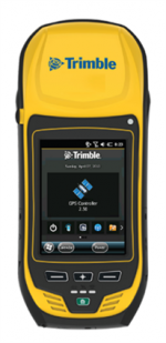
Trimble introduced today the next generation of its Trimble GeoExplorer data collection solution. The new Geo 7X includes an integrated laser rangefinder module, extended GNSS capabilities and improved hardware performance. Together with robust field and office software, the new Trimble Geo 7X handheld can enhance productivity in difficult physical conditions and challenging GNSS environments.
Monday, November 4th, 2013
3-GIS, an Alabama based GIS software development company, has announced they’ve released their mobile software called 3-GIS Mobile 2.1 with Android compatibility. 3-GIS worked with Gas Technology Institute (GTI)—a leading research and development organization serving energy and environmental markets—and Operations Technology Development (OTD)—a partnership of natural gas distribution companies formed to develop, test, and