DigitalGlobe recently reached a major milestone – the company’s archive surpassed 4 billion square kilometers of high-resolution satellite imagery. As the leader in commercial satellite imagery content, DigitalGlobe now has an archive containing enough imagery to cover the globe’s landmass 27 times over.
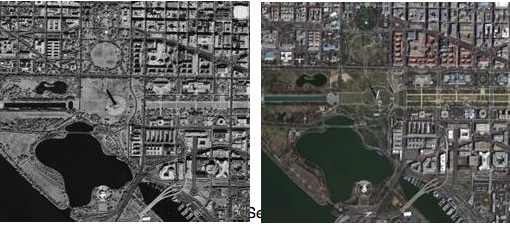 At left is the first satellite image taken by Ikonos, the first commercially-available high-resolution imaging satellite. At right is an image of the same area in Washington, D.C., taken by GeoEye-1 on March 23, 2013.
“In this imagery archive is practically every building, every car, every ship, every port, every house, every glacier, every mountain, hill and river on the Earth,” according to Dr. Walter Scott, founder and CTO of DigitalGlobe. “It is as if we have a time machine with which to view our rapidly changing planet.”
With its current five satellite constellation, DigitalGlobe is adding a billion square kilometers every year to the imagery archive, an area expected to increase even further with the launch of its newest satellite, WorldView-3, next year.
