Sensors and Systems
Breaking News
Terran Orbital’s Tyvak International Centauri-6 Satellite Successfully Deployed into Orbit
TURIN, Italy – Tyvak International SRL (“Tyvak International”), a...
Overture Maps Foundation Releases Beta of Its First Open Map Dataset
Production-ready 1.0 version expected to unleash untold mapping services...
ideaForge introduces breakthrough Border Protection and Public Safety solutions for the US market
 Tackling security and Public Safety Challenges across the United States...

hurrican

image

Monday, October 9th, 2017

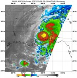
Satellites Provide Thermal View of Hurricane Nate after Landfall

NASA’s Aqua satellite and NASA-NOAA’s Suomi NPP satellite analyzed the temperatures in Hurricane Nate’s cloud tops and determined that the most powerful thunderstorms and heaviest rain areas were around the center of the tropical cyclone after it made landfall near the mouth of the Mississippi River on Oct. 7, 2017. Infrared light provides valuable temperature