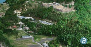
Montreal, Canada, August 6th, 2019 – SimActive Inc., a world-leading developer of photogrammetry software, announces that Correlator3D™ is being used in Japan for mapping projects acquired by the DJI Phantom 4 RTK. A full-scale validation was done in the mountains near Hiroshima with a unit flown by SimActive Japanese partner Mirukuru and customer Ace-1.
“Considering that the data were acquired and processed directly in the field in a record time, the level of details that are visible and measurable in Correlator3D™ is stunning”, said Mr Shinji Inaba, Technical Manager at Mirukuru Co. Ltd., Japan. “We had independently set up five check points and the residuals are consistently in the 5cm-range, both horizontal and vertical.”
“The area was surveyed by two independent flights at different altitude to assess consistency using Correlator3D’s change detection module”, said Mr Francois Gervaix, Technical Advisor at SimActive. “The analysis was very simple to achieve, and 3D profiles showed no bias and very limited noise.”
About Mirukuru Co. Ltd
Mirukuru is a technical consultant, reseller and support provider for photogrammetry and LiDAR Mapping solutions based in Tokyo, Japan. With 20 years of experience, the Mirukuru team is committed to provide the highest product quality and support to its customers. For more information, visit www.mirukuru.co.jp.
About SimActive
SimActive is the developer of Correlator3D™ software, a patented end-to-end photogrammetry solution for the generation of high-quality geospatial data from satellite and aerial imagery, including UAVs. Correlator3D™ performs aerial triangulation (AT) and produces dense digital surface models (DSM), digital terrain models (DTM), point clouds, orthomosaics, 3D models and vectorized 3D features. Powered by GPU technology and multi-core CPUs, Correlator3D™ ensures matchless processing speed to support rapid production of large datasets. SimActive has been selling Correlator3D™ to leading mapping firms and government organizations around the world, offering cutting-edge photogrammetry software backed by exceptional customer support. For more information, visit www.simactive.com.
