NEWTON, MASSACHUSETTS (USA) – The Maptitude 2020 Geodemographic Segmentation data for the USA are available now. Out-of-the-box, Maptitude provides detailed data for the entire country. The addition of a comprehensive and free demographic segmentation ensures that Maptitude will continue to be at the forefront of the location intelligence revolution.
Maptitude allows you to target a lifestyle within an area, find the lifestyle composition of a given area or around a location, isolate demographic segments or subsegments, and identify the key populations driving the growth of your most successful sites.
The 8 segments and 32 subsegments provide an intuitive way to explore the demographic makeup of neighborhoods across the country. These locations can be analyzed with the tools and data included with Maptitude, such as spatial/SQL filters, reports, and radius/ring tools.
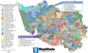
The ability and desire to perform geographic micromarketing or “local marketing” has been rapidly increasing. But making sense of spatial patterns to identify ideal populations is a daunting task for most market research analysts. The Maptitude Geodemographic Segmentation presents demographic data in a way that is easy to visualize and interpret, allowing you to identify potential business or franchise locations.
The Geodemographic Segmentation data will help you discover target markets that you didn’t even know you had! Using the data, you can export meaningful demographic descriptions for your territories and create attractive maps that clearly show business opportunities.
The data are also available as shapefile, KML, KMZ, or GeoJSON for a fee. If you have any questions about Maptitude or data availability contact the Maptitude team.
