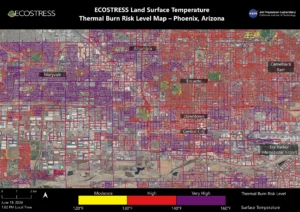
 Researchers at NASA’s Jet Propulsion Laboratory in Southern California mapped scorching pavement in Phoenix where contact with skin—from a fall, for example—can cause serious burns. The image shows land-surface temperatures across a grid of roads and adjacent sidewalks, revealing how urban spaces can turn hazardous during hot weather.
Data for this visualization of the Phoenix area—the fifth most populous city in the United States—was collected on June 19, 2024, by a NASA instrument aboard the International Space Station. Called ECOSTRESS (short for the Ecosystem Spaceborne Thermal Radiometer Experiment on Space Station), the instrument measures thermal infrared emissions from Earth’s surface.
The image shows how miles of asphalt and concrete surfaces (colored here in yellow, red and purple, based on temperature) trap heat. The surfaces registered at least 120 degrees Fahrenheit (49 degrees Celsius) to the touch—hot enough to cause contact burns in minutes to seconds.
The image also shows cooling effects of green spaces in communities such as Encanto and Camelback East, in contrast to the hotter surface temperatures seen in Maryvale and Central City, where there are fewer parks and trees.
Image Credit: NASA/JPL-Caltech
