MDA’s Information Systems group announced today that it is making available a series of RADARSAT-2 flood maps to any local, provincial, or federal agency or non-profit organization that is involved in responding to the recent flooding in Alberta.
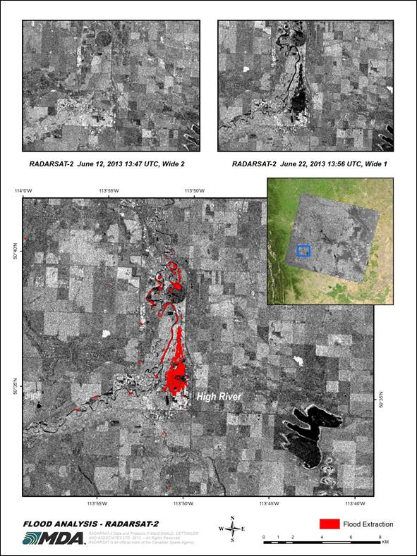
David Belton, the General Manager for MDA’s Geospatial Services business spoke about this major event. “The flood events in and around southern Alberta were declared the largest in the province’s history. It has caused immense devastation to Calgary, High River and the surrounding region and has delivered untold damage to the people that live there. Belton further added, “When the flooding started, the Canadian Government initiated a number of RADARSAT-2 acquisitions of the surrounding region. This new imagery allows us to match the acquisitions of the flooding with imagery from our extensive archive to build a series of flood maps that can help the groups that are responding to this disaster.”
RADARSAT-2 is a high resolution Synthetic Aperture Radar (SAR) satellite that is ideally suited to developing flood products that clearly delineate the extent of flood waters by comparing images from before the flooding took place, with images from the height of the flooding to give organizations responsible for responding to the event details about the flood extents. Covering large areas at a high resolution, RADARSAT-2 based flood maps are ideal for assisting in situations like the Alberta floods. The flood products cover an area from Calgary through to High River, and clearly show the extent of the flood. They are available as both PDF reports that provide detailed information about the flooding, as well as geospatial data that can be used for more comprehensive analysis within a Geographic Information System (GIS).
Organizations that would like to get copies of these files can contact the MDA Geospatial Services Customer Service group:
E-mail: [email protected]