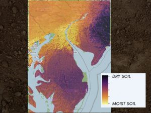
New techniques add more precision and accuracy to soil moisture maps.
Trying to gauge soil moisture across large areas—regions, nations, continents—is difficult, yet knowledge of this dimension of our ecosystem is extremely important for farmers, planners, scientists, insurance companies and anyone concerned about preparing for global environmental change.
“Understanding these patterns is critical to national and international security,” said Rodrigo Vargas, associate professor of ecosystem ecology and environmental change in the Department of Plant and Soil Sciences at the University of Delaware. “We cannot measure everything everywhere all the time. So we are using alternative approaches, such as machine learning that helps us get insight from complex sets of data.”
Vargas and doctoral student Mario Guevara have developed a new approach that sharpens our ability to predict soil moisture, even in large areas where no data have been available. Compared to standard estimates produced by satellite-based sensors, the new approach increases the accuracy of these estimates by more than 20 percent. It also makes it possible to predict soil moisture conditions in much smaller areas and in greater detail than standard models have been able to show. They described their work in a recent issue of PLOS ONE, a peer-reviewed journal published by the Public Library of Science.
