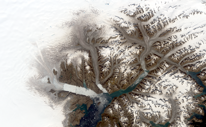
Glaciers in southeastern Greenland including, from left, Helheim, Fenris and Midgard are seen in a Landsat 8 image from Aug. 12, 2019 (top left image), and a composite image from Landsat 1 scenes collected in September 1972 (top right image). Comparing images across the span of the Landsat mission provides a record of almost five decades of change to this region of southeast Greenland. (Credit: NASA/Christopher Shuman)
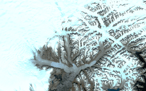
Ice fronts have retreated, rocky peaks are more exposed, fewer icebergs drift to the ocean: the branching network of glaciers that empty into Greenland’s Sermilik Fjord has changed significantly in the last half century. Comparing Landsat images from 1972 and 2019, those changes and more come into view.
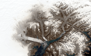
The glaciers appear brownish grey in this true-color Landsat 8 satellite image from Aug. 12, 2019. The color indicates that the surface has melted, a process that concentrates dust and rock particles and leads to a darker recrystallized ice sheet surface.
The darker melt surface in 2019 extends much farther onto the ice sheet than it did in 1972, when the first Landsat satellite gathered data on the area, said Christopher Shuman, a glaciologist with the University of Maryland, Baltimore County, at NASA Goddard Space Flight Center in Greenbelt, Md. Landsat is a joint mission of NASA and the U.S. Geological Survey.
Helheim Glacier, one of the largest and fastest flowing of its kind in Greenland, has retreated approximately 4.7 miles (7.5 kilometers) up a wide fjord in the time between the two scenes, leaving a jumble of sea ice where its calving front used to be. To the east, Midgard Glacier has retreated approximately 10 miles (16 kilometers), splitting into two branches farther up the fjord. Changes to the rocky outcrops of the area’s mountains and smaller tributary glaciers are also visible by comparing the two Landsat images.
CAPTION
Glaciers in southeastern Greenland including, from left, Helheim, Fenris and Midgard are seen in a Landsat 8 image from Aug. 12, 2019 (top image), and a composite image from Landsat 1 scenes collected in September 1972 (bottom image). Comparing images across the span of the Landsat mission provides a record of almost five decades of change to this region of southeast Greenland. (Credit: NASA/Christopher Shuman)


