By the beginning of the 2013 fire hazardous season WWF Russia prepared an open interactive resource called “Satellite-based monitoring of fires at the Far East of Russia”. This service operates based on “Geomixer” technology, developed by ScanEx RDC.
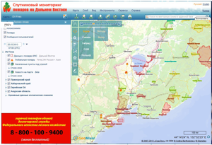 The web-mapping service fires-dv.kosmosnimki.ru is intended for quick detection of forest and grassland fires on the territory of the entire region with the positioning accuracy of up to 10 meters.
Three alternative data sources about fires are used in it: FIRMS system, SFMS system and EMERCOM data (ИАПУ ДВО РАН) with updating frequency of 6 times per day.
— This is exactly the case, when the information received on time may protect valuable forest areas, tiger and leopard habitat areas from fires. I believe the advantages of this web-resource will very soon be appreciated by the employees of the protected natural areas, which have extensive forest areas far away from human settlements and roads,- says the resource creator, WWF Russia Amur Branch GIS-projects coordinator Andrei Purekhovsky.
The project is prepared together with the ScanEx company based on the Web-GIS Geomixer software, enabling any user to view web maps and to take active part in its contents correction and updating.
Thematic layers lists allow quickly localizing the fire source: detecting both its geographic coordinates and the number of the forest quarter, finding the forest fund operators, hunting farms or land user, on which territory the fire started.
Detailed maps of road and water sources, as well as wind direction and speed data can be used for planning firefighting operations.
A special module enables to generate warning messages (sms and e-mail) in case a fire is approaching the borders of a protected natural area or a settlement.
Thanks to the ability to use space image in near real-time, the fire progress monitoring can be arranged, and burnt areas and damage calculated.
The event history enables to save data for the whole fire hazardous period and to use it later on for legal proceedings.
Any user may add messages about a detected fire onto the web-map by using the web-resource “Rynda” (http://rynda.org/) or by making a phone call to the dispatch center of the Forestry Agency at:8-800-100-9400 (free of charge)
