Sunday, March 2nd, 2008
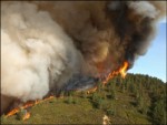
Santa Barbara, Calif. has a long history of fires—from the destructive blazes that were sparked by the great 1906 San Francisco earthquake to more recent wildfires in heavily populated San Diego, San Bernardino, and Los Angeles counties. In 2007, the state endured one of its most damaging forest fires in history: the Zaca fire.

Monday, February 25th, 2008
Zero Carbon House is a project to deliver a low energy house. It is located on the Shetland Islands in northern UK. The project has been gaining much attention and much support. Plans have been developed to include solar and wind generation and a unique horticultural area as well. Vector1Media asked Michael Rea, the owner
Sunday, December 2nd, 2007
Synthetic Aperture Radar (SAR) data is providing valuable information about land use and the environment. With the arrival of new spacreborne and airborne platforms these applications are predicted to expand and grow. New processing software and techniques for SAR data are providing valuable information about weather related events, volcanic activity, seismic and subsidence activity as
Monday, November 12th, 2007
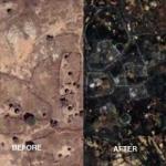
Amnesty International recently launched Eyes on Darfur, an innovative and powerful website utilizing photographs and high-resolution satellite imagery to communicate the crisis in the Darfur region of Sudan. The satellite images track human rights violations before and after reported attacks, highlighting changes in homes and vegetation in villages throughout the region. While the images only

Sunday, November 11th, 2007
The Tempus program stands for “changes in higher education through people to people cooperation”. The program funds cooperation projects in the areas of curriculum development and innovation, teacher training, university management, and structural reforms in higher education. It also facilitates mutual learning between regions and peoples and understanding between cultures by putting special emphasis on
