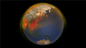
 Geolabe—a prize winner in the 2023 Entrepreneurs Challenge—developed a way to use artificial intelligence to identify global methane emissions. Methane is a greenhouse gas that significantly contributes to global warming, and this promising new technology could provide data to help decision makers develop strategies to mitigate climate change.
The Geolabe team developed a deep learning architecture that automatically identifies methane signatures in existing open-source spectral satellite data and deconvolves the signal from the noise. This AI method enables automatic detection of methane leaks at 200kg/hour and above, which account for more than 85 percent of the methane emissions in well-studied, large oil and gas basins. Information gained using this new technique could help inform efforts to mitigate methane emissions on Earth and automatically validate their effects.
This image taken from a NASA visualization shows the complex patterns of methane emissions around the globe in 2018, based on data from satellites, inventories of human activities, and NASA global computer models.
Credit: NASA’s Scientific Visualization Studio
