For the second year in a row, farmers in Maryland planted a record amount of winter cover crops in 2016-17. These cold-tolerant crops—including wheat, rye, barley and radish—are planted in the fall. In addition to increasing soil health and boosting yields, cover crops reduce soil erosion and absorb nutrients such as nitrogen that could otherwise affect water quality in waterways and, ultimately, Chesapeake Bay.
While most of their cover crop work happens on the ground, farmers get some help from space. Scientists at the USDA-Agricultural Research Service, the U.S. Geological Survey, and the Maryland Department of Agriculture are using data and imagery collected by satellites to monitor cover crop performance, to determine how effective the crops are in protecting the Bay, and to develop strategies that maximize benefits to growers and the environment while minimizing costs.
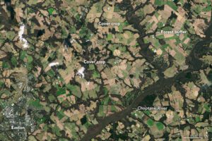
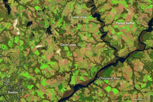
The Operational Land Imager (OLI) on Landsat 8 captured natural-color (upper) and false-color (lower) images on Jan. 5, 2015. They show winter cover crops being grown on farmland along Tuckahoe Creek and the Choptank River on the Delmarva Peninsula. Landsat observations of shortwave infrared, near-infrared, and red light (bands 6, 5, 4) were used to make the false-color image. Fields with healthy cover crops appear bright green in false-color; fallow fields are brown. Forested areas, generally along streams, are dark green.
