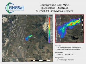
 An optical sensor that can map methane emissions from space at a resolution 100 times higher than any other sensors was deployed on Jan. 20, 2021, with the successful launch of satellite Hugo from GHGSat. The new greater granularity will allow the identification of the source of emissions, rather than just the general area.
The ABB-supplied sensor will provide valuable insights that will enable governments and industries around the world to meet their emission-reduction targets and reduce the negative impact on global warming.
