St. Paul, Minnesota – This afternoon, Minnesota based nonprofit SharedGeo updated its online COVID-19 information map by adding two new features. In addition to the time lapse view of the virus spread across the United States by county since early March, now available is a national map and by state graphs showing progress toward “flattening the curve”.
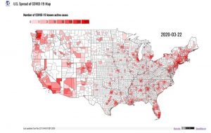
In announcing these developments, SharedGeo indicated this public service effort was underway out of concern many Americans were failing to take the situation seriously. Consequently, it hoped that by visually demonstrating to citizens the rapidly expanding nature of the COVID-19 virus pandemic in the U.S., individuals and organizations would take to heart the warnings, precautions and preventive measures requested by the Centers for Disease Control and Prevention and others in the medical and Public Health sectors. SharedGeo will update these displays going forward as source data is refreshed.
To view the maps, graphs, and learn more, go here: www.uscovid-19map.org.
About SharedGeo: SharedGeo is a Minnesota 501(c)3 nonprofit dedicated to helping government, nonprofit, education, and corporate entities use mapping technologies and share geographic data for the public good. Past and current project partners include federal, state, tribal, county, municipal, nonprofit, and corporate entities. www.sharedgeo.org
