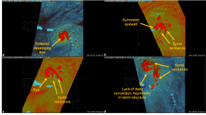
Studying hurricanes (such as Hurricane Dorian) using microwaves allows meteorologists to peer through the cloud tops and into the internal structure of the storm. It allows forecasters to make more-accurate predictions and help save lives. (Credit: NASA/SPoRT)
NASA has for years used its cutting-edge space-based and airborne instruments to better understand hurricanes and give weather forecasters new insights they could use to improve the accuracy of their storm forecasts. A NASA program focused on bringing new weather research to bare on forecasting challenges is now tackling predictions of a hurricane’s strength.
The Short-term Prediction Research and Transition (SPoRT) team based at NASA’s Marshall Space Flight Center in Huntsville, Ala., bridges the weather research and operational forecasting communities. SPoRT team members work closely with forecasters to understand how NASA technologies and data can help them make more-accurate predictions. The process is a continual conversation between researchers and forecasters to develop, refine and use new tools and datasets.
SPoRT is working on new or better ways to incorporate existing satellite data into hurricane intensity forecasts, with the ultimate goal to provide the best information to those in the path of the storm.
