Montreal, Canada, May 14th, 2019 – SimActive Inc., a world-leading developer of photogrammetry software, announces that Correlator3D™ is being used for mapping projects acquired by Wingtra and its high-end vertical take-off and landing drone WingtraOne.
“The high-quality data collected with our WingtraOne PPK drone is well supported by the rigorous workflow of Correlator3D™”, said Basil Weibel, CRO at Wingtra. “Our customers can generate extremely good quality maps and surface models on the SimActive platform even for very large projects.”
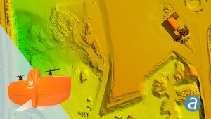
“SimActive software and WingtraOne imagery is a great match, combining high accuracy and very high resolution”, said Francois Gervaix, Technical Advisor at SimActive. “As an example, the combination allows for accurate volume calculation and extraction of spotless contour lines.”
About Wingtra
Headquartered in Switzerland, Wingtra is the world’s leading VTOL drone producer for mapping, survey and mining industry professionals. Since its market entry in early 2017, Wingtra has partnered with more than 50 of the biggest equipment dealers and has been selling mapping drones globally ever since. For more information, visit www.wingtra.com.
About SimActive
SimActive is the developer of Correlator3D™ software, a patented end-to-end photogrammetry solution for the generation of high-quality geospatial data from satellite and aerial imagery, including UAVs. Correlator3D™ performs aerial triangulation (AT) and produces dense digital surface models (DSM), digital terrain models (DTM), point clouds, orthomosaics, 3D models and vectorized 3D features. Powered by GPU technology and multi-core CPUs, Correlator3D™ ensures matchless processing speed to support rapid production of large datasets. SimActive has been selling Correlator3D™ to leading mapping firms and government organizations around the world, offering cutting-edge photogrammetry software backed by exceptional customer support. For more information, visit www.simactive.com.
