 NASA’s Global Ecosystem Dynamics Investigation (GEDI) mission launched in December 2018. From its perch aboard the International Space Station, GEDI’s powerful lasers create detailed 3D maps of Earth’s forests and topography, providing innovative and unique spaceborne observations. In January 2019, GEDI’s lasers were turned on for the first time, and the instrument is now giving scientists a first glimpse of the insights it will provide in the coming years.
GEDI’s mission provides scientists detailed information about forest structure: How tall the forest is, how dense its branches are, and the vertical and horizontal distribution of its foliage. All this yields crucial insights into Earth’s global carbon cycle by fostering a better understanding of how forests store carbon and what happens to that carbon when they are cut down or disturbed. Forests support numerous plant and animal species, and understanding their structure can help biologists better understand Earth’s forest habitats and biodiversity.
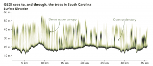
When scientists process GEDI data, the resulting measurements reveal the vertical structure of the forest. The GEDI image below is of a South Carolina woodland where darker green shows where the leaves and branches are denser, while the lighter areas show where the canopy is less dense.
Image Credits: Joshua Stevens/NASA Earth Observatory, Bryan Blair/NASA Goddard Space Flight Center, Michelle Hofton and Ralph Dubayah/University of Maryland
