Sensors and Systems
Breaking News
The Release of UgCS 5.0 is Setting New Standards in Drone Flight Planning
The most significant release of UgCS, the best and...
ModalAIⓇ Launches Next Generation Starling 2 and Starling 2 Max NDAA-Compliant Development Drones
SAN DIEGO – ModalAI, Inc. today announced Starling 2...
Draganfly, Doodle Labs, and UXV Technologies Collaborate to Enhance UAV Communication Solutions
Innovative Collaboration Between Draganfly, Doodle Labs, and UXV Technologies...

water supply

image

Thursday, August 25th, 2016

Esri Maps NOAA’s National Water Model

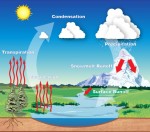
New Real-Time Maps Transform Forecast Data into Vivid Pictures of U.S. River Flows REDLANDS, Calif.—August 25, 2016—Smart-mapping leader Esri today released a beautiful, robust new collection of Web maps that forecast NOAA stream-flow data throughout the continental U.S. Esri’s multiscale visualization of the National Water Model enables forecast water flows in real time at high