Sensors and Systems
Breaking News
The Release of UgCS 5.0 is Setting New Standards in Drone Flight Planning
The most significant release of UgCS, the best and...
ModalAIⓇ Launches Next Generation Starling 2 and Starling 2 Max NDAA-Compliant Development Drones
SAN DIEGO – ModalAI, Inc. today announced Starling 2...
Draganfly, Doodle Labs, and UXV Technologies Collaborate to Enhance UAV Communication Solutions
Innovative Collaboration Between Draganfly, Doodle Labs, and UXV Technologies...

Nate

image

Monday, October 9th, 2017

Satellites Provide Thermal View of Hurricane Nate after Landfall

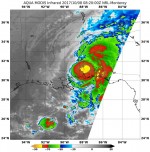
NASA’s Aqua satellite and NASA-NOAA’s Suomi NPP satellite analyzed the temperatures in Hurricane Nate’s cloud tops and determined that the most powerful thunderstorms and heaviest rain areas were around the center of the tropical cyclone after it made landfall near the mouth of the Mississippi River on Oct. 7, 2017. Infrared light provides valuable temperature