Thursday, September 5th, 2013
Scientists are expecting a very large “dead zone” in the Gulf of Mexico and a smaller than average hypoxic level in the Chesapeake Bay this year, based on several NOAA-supported forecast models.
Tuesday, August 27th, 2013
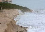
Beaches and dunes on Fire Island, New York, lost more than half of their pre-storm volume during Hurricane Sandy, leaving the area more vulnerable to future storms. While the damage and destruction on Fire Island was immediately evident after the storm, a new U.S. Geological Survey study released today is the first to quantify the
Sunday, August 11th, 2013
Science and technology have peeled back a veil of water just offshore of California, revealing the hidden seafloor in unprecedented detail. New imagery, specialized undersea maps, and a wealth of data from along the California coast are now available. Three new products in an ongoing series were released today by the U.S. Geological Survey —
Tuesday, July 30th, 2013
Summer can be a tough time for many species in the Gulf of Mexico, when the combination of nutrient-rich river runoff and warm temperatures can rob coastal bottom waters of oxygen. Where that happens, shrimp, fish, and other creatures can be forced to flee to fresher waters, leaving a so-called dead zone behind.
Monday, July 1st, 2013
The probability of hurricane-induced coastal change on sandy beaches from Florida to New York has been assessed for the first time in two U.S. Geological Survey studies released today. The two reports — one assessing the coastline from Florida to North Carolina, the other from Virginia to New York — can function as part of
Tuesday, June 18th, 2013
Scientists are expecting a very large “dead zone” in the Gulf of Mexico and a smaller than average hypoxic level in the Chesapeake Bay this year, based on several NOAA-supported forecast models.
Friday, May 17th, 2013
A new study of glaciers worldwide using observations from two NASA satellites has helped resolve differences in estimates of how fast glaciers are disappearing and contributing to sea level rise. The new research found glaciers outside of the Greenland and Antarctic ice sheets, repositories of 1 percent of all land ice, lost an average of
Friday, May 10th, 2013
The 2013 spring and summer red tide reason in New England is expected to be “moderate” according to NCCOS’s partner, the Woods Hole Oceanographic Institution (WHOI), forecast last month. Ocean and weather data from the Gulf of Maine buoys play an important role in this forecasting effort. When developing this new red tide forecast system, scientists depended on historical
Tuesday, April 30th, 2013
NOAA is using data from a new current meter in New York harbor, operated by one of its academic partners, New Jersey’s Stevens Institute of Technology, to provide enhanced real-time information to mariners travelling through the nation’s second busiest port.
Tuesday, April 30th, 2013
More than 800 acres of uplands in and near Acadia National Park will likely be flooded by the ocean if sea level rises 2 feet during this century, leaving 75 percent of the saltwater marshes along this part of central Maine’s rugged coast with very little upland area to migrate into, according to a new
