Sensors and Systems
Breaking News
On Earth Day and Every Day The Gloria Barron Prize for Young Heroes Encourages Youth to Save the Planet
The Gloria Barron Prize for Young Heroes is a...
Leica Geosystems launches its first Machine Smart Antenna — the Leica iCON gps 120
Heerbrugg, Switzerland) Leica Geosystems, part of Hexagon, today announced the...
Descartes Labs Government Launches Retina at GEOINT 2024, Fusing OSINT and GEOINT into a Single Pane of Glass
SANTA FE, New Mexico – Descartes Labs Government (DLG) is...

Egypt

image

Monday, November 14th, 2016

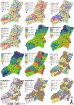
Geospatial Science Identifies High-Risk Flooding Areas in Egypt

Researchers from UT Dallas and other universities developed geospatial science methods to help the Egyptian government determine how to avoid flooding in a coastal mountain region. The government wants to develop the area for tourism, but flash flooding and associated hazards have hampered efforts, according to Dr. May Yuan, Ashbel Smith professor of GIS. “We