A new report outlines the challenges and opportunities facing the geospatial sector and urging “immediate action, collaboration and commitment”.
The UK-based Association for Geographic Information’s (AGI) Foresight Report 2030 puts the spotlight on six interconnected factors which, it says, “challenge every assumption about geospatial intelligence in the 21st century”.
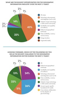
Those six factors or forces are:
All of them will, according to the report, produce the “most significant transformation in geospatial data since the advent of digital mapping”.
“To quote the Foresight Report 2030 ‘we are at an important inflection point for our industry, and it is every leader’s role to take these changes seriously,” said Peter ter Haar, co-chair of the AGI.
“Without productive adaptation, the geospatial sector risks becoming infrastructure that others control — essential but invisible, powerful yet struggling to articulate its value.
“This is a stark warning, and one that government, industry and professional bodies, like the AGI, need to be acting upon with urgency.”
The report’s authors cite Aaron Addison from the World Geospatial Industry Council, who has warned that “The likelihood that somebody from outside the industry will solve our problems increases dramatically” unless co-ordinated action is taken.
Addison has also advocated for the need for the industry to produce professionals “who understand business strategy rather than just technical implementation,” warning that top talent is being poached by hedge funds offering US$400,000-plus salaries.
The Report was launched in front of an audience of more than 200 geospatial professionals at the AGI Foresight 2025 Conference at the Royal Geographical Society (with IBG) in London.
Keynote presenters included Ed Parsons, Google’s first ever Geospatial Technologist, and Denise McKenzie, past chair of the AGI and managing partner at the PLACE Trust.
Findings
The report was 12 months in the making, with the AGI first conducting a quick survey to gauge the main challenges and opportunities within the sector, followed by an analysis of the 92 survey responses.
The AGI then conducted 30 in-depth interviews plus focus group discussions with a variety of leaders.
All of this information was then collated and written up by the two independent authors.
The report makes some interesting observations regarding progress or lack of it over the 10 years since the last such report was published.
For instance, the importance of open data has reached or exceeded expectations, while innovative technologies such as AI and data analytics have far exceeded expectations… driven, the authors say, largely by the needs presented by the COVID-19 pandemic.
Conversely, the uptake and progress of BIM has “not progressed as rapidly as anticipated,” nor have ‘future cities’ ambitions born as much fruit as hoped.
In addition, the previous report completely failed — understandably — to anticipate the generative AI revolution.
As well, the “prediction that ‘general skills of using geographic information (GI) in data analysis have broadened as GI has become more mainstream’ proved accurate, but underestimated how radically AI would change skill requirements,” the authors say.
Commenting on the report’s findings, David Henderson, Chief Geospatial Officer at Ordnance Survey, said that “As a geospatial community, we must embrace AI, ensure data is trusted and traceable, and accelerate our commitment to future skills to enable better decisions across all sectors”.
One of the most interesting chapters in the report is the one dedicated to ‘voices from the margin,’ which outlines “blind spots in our collective vision of spatial intelligence’s future,” the authors write.
This includes “defence practitioners questioning open data orthodoxy, healthcare professionals re-imagining human-AI collaboration, and humanitarian workers challenging Western data standards”.
Roadmap
The report concludes with a five-year roadmap for geospatial transformation that “synthesises the most critical interventions required from government, industry, and professional bodies to ensure geospatial expertise remains central to addressing 21st-century challenges”.
The roadmap splits the job into three parts: government, industry and industry organisations.
For government, years 1 and 2 of the roadmap involve development of a foundational framework to improve geoAI literacy, establishing comprehensive data governance for the AI era and reforming licensing and access models for API-drive integration.
Years 2 and 3 should focus on investment in education and skills by embedding spatial reasoning in national curricula and ensuring strategic infrastructure investment.
This should be followed in years 3 to 5 by mandating climate and environmental disclosures and showing leadership on international standards.
For industry, years 1 and 2 should be devoted to building provenance-aware AI systems, developing sustainable access models and investing in hybrid collaboration models.
Years 2 and 3 should see the fostering of cross-sector integration platforms and action to address the critical skills gap.
This would be followed in years 3 to 5 by championing responsible AI development.
For industry organisations, the first two years should be devoted to championing geography over geospatial specialisation, bridging sectoral divides and improving communication of the value of geospatial.
Years 2 and 3 would see a modernisation of professional competency frameworks, the enabling of evidence-based advocacy and fostering next-generation workforce development.
