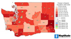
NEWTON, MA (USA) – Maptitude U.S. County Projection Data 2020-2100 are available and includes 2,448 columns of nationwide cross-tabulated demographics by age, race, gender, and ethnicity.

The new data allow you to target areas by growth using demographic forecasts by 5-year increments out to 2100. These detailed projections are perfect for site location, competitive analysis, marketing campaigns and any kind of analysis that involves considering future population counts. This wealth of data can be leveraged by marketers and business analysts using Maptitude mapping software, a comprehensive application for data exploration.
The County Projections data are free for Maptitude 2020 users, and are also available as shapefile, KML, KMZ, or GeoJSON for a fee. If you have any questions about Maptitude or data availability contact the Maptitude team.
About Caliper
Caliper Corporation develops state-of-the-art Geographic Information Systems (GIS) software. With a focus on usability, Maptitude is designed to be a cost-effective, professional mapping software product. Maptitude enables organizations to leverage their location-based data to improve decision making and planning, while minimizing expenditure through competitively priced solutions.
Caliper is a privately held corporation and is a leading developer of mapping, redistricting, transportation, and GIS software