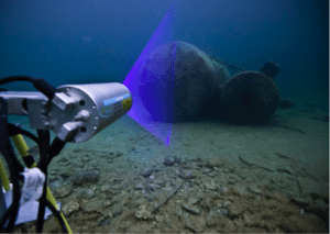
 OceanGate Inc., a provider of manned submersible services, and 2G Robotics, which develops underwater laser scanners, formed a strategic alliance to capture laser data of the RMS Titanic shipwreck and debris field. 2G Robotics ULS-500 PRO underwater laser scanner will be installed on OceanGate’s Cyclops 2, the first manned submersible to survey the Titanic since 2005.
The six-week Titanic Survey Expedition will depart from St. John’s, Newfoundland, Canada, in June 2018 with scientists, content experts and mission specialists joining the crew in a series of week-long missions. The 2G Robotics equipment will generate real-time 3D models with millimetric resolution. Using the highly accurate laser data, the team will overlay 4K images captured throughout the expedition to create a detailed 3D virtual model of the wreck. This model will serve as an objective baseline to assess the decay of the wreck over time as well as help document and preserve its submerged history.
“Laser scanning provides maximum detail in less time than other techniques,” noted Stockton Rush, OceanGate CEO. “2G Robotics has provided us with a solution that will generate an entirely new perspective of the Titanic.”
