Partnerships Across North America, Europe, and Asia Extend Survey-Grade Reality Capture and Digital Twin Solutions for Infrastructure Professionals
San Diego, CA — Looq AI, an innovator in ground-based reality capture for surveying, engineering, and utilities, today announced the expansion of its global partner ecosystem with seven new partnerships across North America, Europe, and Asia. These collaborations bring Looq AI’s fast, easy-to-use, survey-grade capture technology to new markets worldwide.
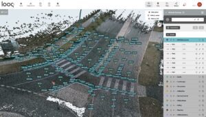
The Looq Platform’s virtual surveying provides a unified, end-to-end workflow, enabling users to efficiently draft, code, and control 3D features while easily exporting clean linework. Image courtesy of Looq AI.
The expanded network is transforming how professionals digitize and monitor critical infrastructure. It addresses the growing demand for fast, accurate, and intelligent field data capture in environments where aerial methods are limited. By complementing LiDAR and filling coverage gaps, Looq AI enables faster, safer, and more comprehensive field data collection.
The Looq Platform combines innovative hardware with intelligent software, working alongside LiDAR—or, where appropriate, replacing traditional multi-tool workflows—to give surveyors, engineers, and utilities a faster, more precise way to map and model infrastructure assets.
“Our mission is to empower professionals with tools that deliver uncompromising accuracy and measurable efficiency gains, often realized in just days, helping engineering firms reduce project costs and increase margins,” said Dominique Meyer, CEO of Looq AI.
Regional Partner Ecosystem
United States
Europe
India & Middle East
About Looq AI:
Looq AI is a high-growth technology platform company dedicated to advancing critical infrastructure digitization and diagnosis. The company has developed a fundamental new camera technology that makes survey-grade 3D capture cost-effective at scale. The Looq Platform is a handheld, ground-based capture system—offering creation, visualization, analysis, collaboration, and integration capabilities to digitize the built world. Users work more efficiently and get accurate results for topographic mapping and modeling of transmission and distribution assets. Learn more at looq.ai.
For more information on our products and authorized resellers, visit Looq AI’s Partner’s page at https://looq.ai/partners/
