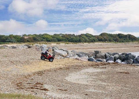
Specialist software supplied by 3D Laser Mapping is being used to process millions of individual laser scanned measurements in order to help protect and conserve the beaches of Sussex on the south coast of England. The TerraSolid software, purchased by Adur and Worthing Councils, is being used to identify and isolate ground points from data collected by a laser scanner mounted on quad bike. These terrain models are then used to create a range of deliverables for the Regional Coastal Monitoring Programme; an extensive integrated survey programme for coastal process monitoring and analysis.
 “The TerraScan software purchased from 3D Laser Mapping will allow us to format, edit and classify our laser scanned data in an efficient and consistent manner,” commented Dan Amos Project Manager for the Strategic Regional Coastal Monitoring Programme at Adur & Worthing Councils. “We can now create TerraScan projects within MicroStation and, using predefined macros, classify and export ground points for onward processing and creation of our deliverables.”
“We are confident that using TerraSolid we will be able to refine our techniques, saving significant amounts of time and producing more consistent results than previously achieved.”
Adur & Worthing Councils regularly survey the beaches between Selsey Bill and Rye Harbour using a mobile laser mapping system mounted on an ATV (all-terrain vehicle). The data is processed and submitted to the Channel Coast Observatory where it is made freely available for use by other Local Authorities within the region, the Environment Agency, consultants in coastal defence, conservation management, academic research and for educational purposes.
In addition to the original supply of the software, 3D Laser Mapping also delivered an onsite training programme to end users at Adur & Worthing Councils. “The training was exactly what we required, informative yet informal. The trainer was clearly experienced in the software and was happy to answer any questions we had at the time and on subsequent occasions” concluded Amos.
The TerraSolid software supplied by 3D Laser Mapping forms part of a suite of solutions specifically designed for the processing of LiDAR (Light Detection and Ranging) and image data from airborne and mobile laser scanning systems. TerraScan is a recognised product within the laser-scanning industry, designed to manage the millions of individual point measurements collected by mapping systems classifying them to user-defined point classes like ground, vegetation and buildings.
3D Laser Mapping is a global developer of laser scanning solutions for sectors such as mapping, mining and manufacturing. 3D Laser Mapping specialises in integrating laser scanning hardware with their own software and peripherals to create solutions at the cutting edge of technology. Through a worldwide network of regional offices and local distributors 3D Laser Mapping is able to provide frontline support and service for a growing international client base. 3D Laser Mapping is also the RIEGL Premier Distributor for the UK, Ireland and sub-Saharan Africa and a leading distributor of TerraScan software. For further information visit www.3dlasermapping.com
Terrasolid offer a range of solutions for data calibration, point classification, image processing and delivery product production – all in a single software environment. TerraScan is a dedicated software solution for processing laser-scanning points and creating fully-featured terrain models. TerraScan can easily handle tens of millions of points as all routines are tweaked for optimum performance and it’s versatile tools prove useful whether you are surveying transmission lines, flood plains, new highway bases, stockpiles, forest areas or urban environments. For further information visit www.terrasolid.com
The Channel Coastal Observatory is the data management and regional coordination centre for the Southeast Regional Coastal Monitoring Programme. The programme provides a consistent regional approach to coastal process monitoring, providing information for development of strategic shoreline management plans, coastal defence strategies and operational management of coastal protection and flood defence. The programme is managed on behalf of the Coastal Groups of the Southeast of England and is funded by DEFRA, in partnership with local Authorities of the southeast of England and the Environment Agency. For further information visit www.channelcoast.org