IRVINE, Calif., – CoreLogic® (NYSE: CLGX), a leading global property information, analytics and data-enabled solutions provider, today released its 2017 Storm Surge Report which shows that nearly 6.9 million homes along the Atlantic and Gulf coasts are at potential risk of damage from hurricane storm surge inundation with a total reconstruction cost value (RCV) of more than $1.5 trillion (Table 1). The reconstruction cost value is the cost to completely rebuild a property in case of damage, including labor and materials by geographic location, assuming a worst-case scenario at 100-percent destruction. Storm predictions indicate the 2017 hurricane season will see fewer storms than both 2016 and the 30-year average. The National Oceanic and Atmospheric Administration (NOAA) predicts 12 total storms, six of which will develop into hurricanes, and three of those are predicted to be Category 3 or higher.
The CoreLogic analysis examines risk from hurricane-driven storm surge for homes along the Atlantic and Gulf coastlines across 19 states and the District of Columbia, as well as for 86 metro areas. Homes are categorized among five risk levels: Low (homes affected only by a Category 5 storm), Moderate (homes affected by Category 4 and 5 storms), High (homes affected by Category 3, 4 and 5 storms), Very High (homes affected by Category 2, 3, 4 and 5 storms) and Extreme (homes affected by Category 1-5 storms).
“Despite the fact that this year’s hurricane season is predicted to have fewer storms than last year, it doesn’t mitigate the risk of storm surge damage,” said Dr. Tom Jeffery, senior hazard scientist at CoreLogic. “As we’ve seen with past storms, even one single hurricane at a lower-level category can cause significant damage if it makes landfall in a highly populated area.”
At the regional level, the Atlantic Coast has 3.9 million homes at risk of storm surge with an RCV of $970 billion, and the Gulf Coast has just under 3 million homes at risk with $593 billion in potential exposure to total destruction damage (Table 2).
At the state level, Texas and Florida – which have the longest coastal areas – consistently have more homes at risk than other states. Again this year, as in previous years, Florida ranks first with just under 2.8 million at-risk homes across the five risk categories, and Texas ranks third with 536,000 at-risk homes (Table 3). Since the number of homes at risk strongly correlates with the accompanying RCV, these two states rank first and fifth, respectively, for having the largest RCV (Table 4). States with less coastal exposure but lower-lying elevations that extend farther inland, such as Louisiana (ranked second at 808,000 at-risk homes) and New Jersey (ranked fourth at almost 470,000 at-risk homes), tend to have more total homes at risk because of the potential for surge water to travel farther inland. Louisiana and New Jersey are also near the top of the list for RCV, with Louisiana totaling almost $181 billion (ranked second) and New Jersey totaling $140 billion (ranked fourth).
At the local level, 15 Core Based Statistical Areas (CBSAs) account for 67.3 percent of the 6.9 million total at-risk homes and 68.6 percent of the total $1.56 trillion RCV (Table 5). This disproportionate distribution of homes suggests that the location of hurricanes that make landfall is often a more important factor than the number of storms that may occur during the year. The Miami CBSA, which includes Fort Lauderdale and West Palm Beach, has the most homes at risk totaling almost 785,000 with an RCV of $143 billion. By comparison, the New York City CBSA has slightly fewer homes at risk at 723,000, but a significantly higher total RCV totaling $264 billion due to the greater home values and high construction costs in this area.
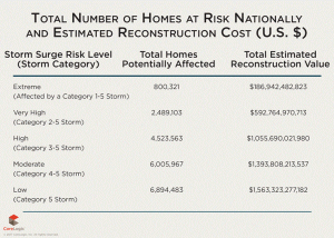
Table 1: Total Number of Homes at Risk Nationally and Estimated Reconstruction Cost Value
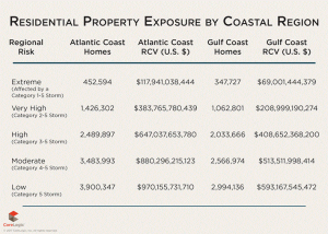
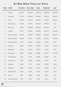
Table 3: Number of Homes at Risk by State
*The Low risk category refers to Category 5 hurricanes which are not common along the northeastern Atlantic Coast. States in that region are designated as N/A for this category due to the extremely low probability of a Category 5 storm affecting that area.
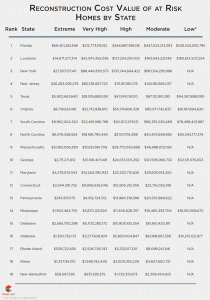
Table 4: Estimated Reconstruction Cost Value by State (U.S. Dollars)
*The Low risk category refers to Category 5 hurricanes which are not common along the northeastern Atlantic Coast. States in that region are designated as N/A for this category due to the extremely low probability of a Category 5 storm affecting that area.
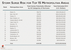
Table 5: Number of Homes at Risk Nationally and Estimated Reconstruction Cost Value by Metropolitan Area
Methodology
The analysis in the 2017 CoreLogic Storm Surge Report encompasses single-family residential structures less than four stories, including mobile homes, duplexes, manufactured homes and cabins, among other non-traditional home types. This does not infer that there will be no damage to residential units greater than 4 stories, as there may be associated wind or debris damage. However, including all high-rise residential units in the CoreLogic analysis would inaccurately inflate the number of homes at risk of storm surge flooding by including homes that are elevated above the potential for damage from surge waters.
Year-over-year changes in the number of homes at risk and RCV can be the result of several variables, including new home construction, improved public records, enhanced modeling techniques, fluctuation in labor, equipment and material costs and even a potential rise in sea level. As a result, direct year-over-year comparisons should be carefully considered. To estimate the value of property exposure of single-family residences, CoreLogic uses its reconstruction cost valuation (RCV) methodology which estimates the cost to rebuild the home in the event of a total loss, and is not to be confused with property market values or new construction cost estimation. Reconstruction cost estimates more accurately reflect the actual cost of damage or destruction of residential buildings that would occur from hurricane-driven storm surge since they include the cost of materials, equipment and labor needed to rebuild and also factor in geographical pricing differences. Actual land values are not included in the estimates. The values in this report are based on 100-percent, or total, destruction of the residential structure. Depending on the amount of surge water from a given storm, there may be less than 100-percent damage to the residence, which would result in a lower realized RCV.
The high-resolution, granular modeling for underwriting individual risk allows enhanced understanding of the risk landscape and damage potentials. CoreLogic offers high-resolution solutions with a view of hazard and vulnerability consistent with the latest science for more realistic risk differentiation. The High-Resolution Storm Surge modeling using 10m Digital Elevation Model (DEM), Structure Footprint and parcel-based geocoding precision from PxPoint™ facilitate a realistic view of the risk.
About CoreLogic
CoreLogic (NYSE: CLGX) is a leading global property information, analytics and data-enabled solutions provider. The company’s combined data from public, contributory and proprietary sources includes over 4.5 billion records spanning more than 50 years, providing detailed coverage of property, mortgages and other encumbrances, consumer credit, tenancy, location, hazard risk and related performance information. The markets CoreLogic serves include real estate and mortgage finance, insurance, capital markets, and the public sector. CoreLogic delivers value to clients through unique data, analytics, workflow technology, advisory and managed services. Clients rely on CoreLogic to help identify and manage growth opportunities, improve performance and mitigate risk. Headquartered in Irvine, Calif., CoreLogic operates in North America, Western Europe and Asia Pacific. For more information, please visit www.corelogic.com.
CORELOGIC, PxPoint, and the CoreLogic logo are trademarks of CoreLogic, Inc. and/or its subsidiaries. All other trademarks are the property of their respective owners.