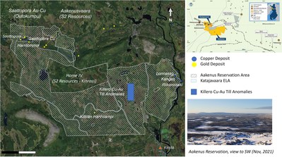
Figure 1. Location of the Katajavaara-Aakenus project, together with known gold-copper deposits and occurrences within the district. The Company’s initial priority target areas are also indicated.
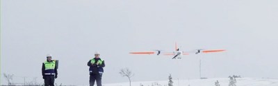
Figure 2. Drone equipment being utilized for the high-resolution magnetic survey.
About the Katajavaara-Aakenus Project
The Katajavaara-Aakenus project covers a total area of 200 square kilometres and is located in the highly-productive Central Lapland Greenstone Belt (“CLGB”) of northern Finland. The CLGB contains numerous occurrences of both gold and base metals, with significant recent discoveries including Ikkari (Rupert Resources) and Aamurusko (Risti-Launi; Aurion Resources)1.
The Company’s initial focus will be on five priority gold and/or copper target areas (see also Company News Release dated December 7, 2021):
- potential extensions to Outokumpu Oy’s Saattopora former gold-copper mining operation, which is entirely surrounded by the Aakenus project;
- potential extensions to S2 Resources’ Aakenusvaarus gold project, which is bounded to the E by the Katajavaara project and to the W by Aakenus;
- the Killero copper-gold (“Cu-Au”) anomaly, where exceptional Cu-Au values were returned from historical Base of Till (“BoT”) drilling by AngloAmerican but never followed up with diamond drilling;
- the Riikonkoski-Lonnakko-Kangas cluster of copper occurrences located along the eastern boundary of the Aakenus project;
- the Kittilan orogenic gold occurrence located in the southern part of the property.
The Company’s projects also flank the S2 Resources-Kinross JV area at Home, where Kinross has the option to earn-in to a 70% interest in Home in return for an exploration investment of USD 9.5M (see S2 Resources’ News Release dated June 3, 2021).
|
1 References made to nearby mines and analogous deposits provide context for the Katajavaara-Aakenus project but are not necessarily indicative that these projects host similar tonnages or grades of mineralization.
|
Qualified Persons and Disclosure Statement
The technical information in this news release relating to the Katajavaara-Aakenus gold-copper project has been prepared in accordance with Canadian regulatory requirements set out in NI 43-101, and approved by Eric Roth, the Company’s President & CEO, a Director, and a Qualified Person under NI 43-101. Mr. Roth holds a Ph.D. in Economic Geology from the University of Western Australia, is a Fellow of the Australian Institute of Mining and Metallurgy (AusIMM) and is a Fellow of the Society of Economic Geologists (SEG). Mr. Roth has 30 years of experience in international minerals exploration and mining project evaluation.
On Behalf of the Board of Capella Minerals Ltd.
“Eric Roth”
___________________________
Eric Roth, Ph.D., FAusIMM
President & CEO
About Capella Minerals Ltd
Capella is engaged in the acquisition, exploration, and development of quality mineral resource properties in favourable jurisdictions with a focus on high-grade gold and copper deposits. The Company’s copper focus is currently on the discovery of high-grade VMS-type deposits within 100%-owned, district-scale land positions around the past-producing Løkken and Kjøli copper mines in central Norway. The Company’s precious metals focus is on the discovery of high-grade gold deposits on its newly-acquired Finnish project (Katajavaara-Aakenus), the 100%-owned Southern Gold Line Project in Sweden, and its active Canadian Joint Ventures with Ethos Gold Corp. (TSXV-ECC) at Savant Lake (Ontario) and Yamana Gold Inc. at Domain (Manitoba). The Company also retains a residual interest (subject to an option to purchase agreement with Austral Gold Ltd) in the Sierra Blanca gold-silver divestiture in Santa Cruz, Argentina.
The Company also holds 3,000,000 common shares in Ethos Gold Corp. providing Capella shareholders with indirect exposure to exploration success at both the Savant Lake Project and elsewhere within Ethos’ extensive Canadian project portfolio.
Cautionary Notes and Forward-looking Statements
This news release contains forward-looking information within the meaning of applicable securities legislation. Forward-looking information is typically identified by words such as: believe, expect, anticipate, intend, estimate, postulate and similar expressions, or are those, which, by their nature, refer to future events. Such statements include, without limitation, statements regarding the future results of operations, performance and achievements of Capella, including the timing, completion of and results from the exploration and drill programs described in this release. Although the Company believes that such statements are reasonable, it can give no assurances that such expectations will prove to be correct. All such forward-looking information is based on certain assumptions and analyses made by Capella in light of their experience and perception of historical trends, current conditions and expected future developments, as well as other factors management believes are appropriate in the circumstances. This information, however, is subject to a variety of risks and uncertainties and other factors that could cause actual events or results to differ materially from those projected in the forward-looking information. Important factors that could cause actual results to differ from this forward-looking information include those described under the heading “Risks and Uncertainties” in Capella’s most recently filed MD&A. Capella does not intend, and expressly disclaims any obligation to, update or revise the forward-looking information contained in this news release, except as required by law. Readers are cautioned not to place undue reliance on forward-looking information.
Neither the TSXV nor its Regulation Services Provider (as that term is defined in the policies of the TSXV) accepts responsibility for the adequacy or accuracy of this release.