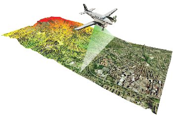
 Aerial surveying company Bluesky has purchased a state of the art airborne mapping system which includes a LiDAR and fully integrated thermal sensor and high resolution camera. The system has been developed by Optech and combines the Orion M300 LiDAR, Long Wave Infrared thermal sensor and a CS-10000 camera.
The LiDAR (Light Imaging Detection and Ranging) system uses aircraft mounted lasers to accurately determine the distance between the sensor and the ground or other targets such as buildings and vegetation. Specifically designed to offer a cost effective, high performance solution at mid altitudes, the Orion M300 is ideally suited for applications such as electricity transmission network mapping, transport infrastructure modelling and environmental monitoring such as flood risk analysis and forestry management. In addition it will enable Bluesky to capture highly accurate 3D measurements from which to create some of their bespoke mapping solutions, such as the UK’s first solar potential map and 3D city models.
The thermal sensor records infrared measurements and will be used for identifying heat loss from buildings and monitoring pipelines. It can be used simultaneously with the LiDAR or independently depending on the customer’s requirements. In addition the camera captures images of the target sites and again can be used simultaneously with the other two sensors providing customers with a wealth of coincident information for their area of interest; a complete solution and substantial acquisition savings.
The system chosen by Bluesky offers industry leading data precision and accuracy and is the world’s most compact system, offering flexibility in installation and use.
“This is an important acquisition for a wide section of our clients. The availability of this sensor in the UK means that Bluesky’s new and existing customers will now benefit from having the very latest aerial technology at their disposal” commented Rachel Tidmarsh, Managing Director of Leicestershire based Bluesky International. “We undertook a rigorous review of all systems currently available before selecting this state of the art system from Optech; which we believe will allow us to fulfil some of the more technically demanding data acquisition projects required by our customers.”