Thursday, May 24th, 2018
WILSONVILLE, Ore. – FLIR Systems, Inc. (NASDAQ: FLIR) today announced the availability of three products for use by global militaries and government agencies including border patrol agents. These products include two FLIR Ranger® mid-range panel radars, one with airborne drone and ground target detection, and the Recon® V UltraLite thermal monocular. The products, unveiled at
Thursday, May 24th, 2018
Calgary, Canada – Hexagon’s Positioning Intelligence division is pleased to announce the latest milestone achieved on the road to safe autonomy. The company’s ground-breaking initiative is on a mission to develop functionally safe positioning technologies for fully autonomous vehicles and other applications. As part of the company’s firm commitment to this mission, a third-party audit
Thursday, May 24th, 2018
Edinburgh, UK – NCTech, a developer of reality imaging systems, today announced the availability of iSTAR Pulsar , the company’s professional edge-to-cloud big data system, optimized for capture on the move. iSTAR Pulsar is designed to capture 360-degree data while mounted on a vehicle, drone or on foot. The system is designed for ease
Thursday, May 24th, 2018
MCLEAN, Va. – Iridium Communications Inc. (NASDAQ:IRDM) announced today that at 12:47:58pm PDT (19:47:58 UTC) SpaceX successfully launched five Iridium NEXT satellites from Vandenberg Air Force Base in California. The Iridium satellites were joined by the twin spacecraft for the NASA/German Research Center for Geosciences (GFZ) Gravity Recovery and Climate Experiment Follow-On (GRACE-FO) mission, in
Thursday, May 24th, 2018
SAN DIEGO – Kratos Defense & Security Solutions, Inc. (Nasdaq:KTOS), a leading National Security Solutions provider, announced today that it has recently received a number of space and satellite communications contract awards totaling approximately $55 million. Work performed under these awards is expected to be substantially completed over the next 12 months. The awards include
Thursday, May 24th, 2018
REDMOND, Wash. – Aerojet Rocketdyne successfully completed hot-fire testing of a new in-space engine, designated ISE-100. Developed for commercial in-space applications, ISE-100 has the potential to be a critical element for future lunar robotic missions. Producing 100 pounds of thrust, the ISE engine has the capability to provide downward thrust during landing, easing spacecraft down
Thursday, May 24th, 2018
Redlands, California—Esri, the global leader in spatial analytics, today announced the opening of a new office in the up-and-coming Waverly neighborhood of Charlotte, North Carolina, in addition to its 3325 Springbank Lane location. The site will be convenient to users in the Southeast interested in learning how to leverage location intelligence and GIS in their
Thursday, May 24th, 2018
REDLANDS, Calif.— Esri, the global leader in spatial analytics, today announced the publication of GIS Tutorial for Crime Analysis, second edition. Readers use Esri ArcGIS software and sample data as they work through step-by-step exercises and independent assignments that teach them how to build and manage a crime mapping and analysis system. Geared toward law
Thursday, May 24th, 2018
The fashion segment enjoyed a 13.5% share of the EU-28’s total stationary retail turnover in 2017. According to GfK’s recent study on European retail, stationary retail and particularly fashion retail are under pressure from e-commerce, off-price concepts, vertically integrated manufacturers competing for end customers as well as rising rental costs in sought-after locations. Even so,
Tuesday, May 22nd, 2018
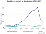
The Northern Sky Research (NSR) Satellite Manufacturing and Launch Services, 8th Edition report finds that despite a slow 2017 across the board, the global satellite manufacturing and launch market is poised to generate more than $250 billion in the next decade. As commercial and government players begin deploying constellations, turning to smallsats to provide more
