Tuesday, June 19th, 2018
BOULDER, Colo. – Ball Aerospace demonstrated its methane remote sensing technology flying on board a piloted aircraft during the Stanford University and Environmental Defense Fund (EDF) Mobile Monitoring Challenge, resulting in high-resolution, geo-referenced imagery of simulated methane leaks in near real-time. The Mobile Monitoring Challenge is a new competition co-sponsored by Stanford University’s Natural Gas Initiative
Tuesday, June 19th, 2018
WESTMINSTER, CO and VANCOUVER – Maxar Technologies Ltd. (“Maxar” or the “Company”, formerly MacDonald, Dettwiler and Associates Ltd.), (NYSE and TSX: MAXR), a leading global provider of advanced space technology solutions for commercial and government markets, announces that it has entered into an agreement to settle all pending litigation with the former holders of 80,000 shares of
Tuesday, June 19th, 2018
Alleroed, Denmark — Contex, the world leader in large format scanning, today introduces the HD Ultra X 6000, the widest, fastest and most productive 60-inch CCD scanner available in the market. Outperforming the competition with color matching and image scanning quality — while exceeding environmental standards — Contex is raising the bar, once again, with
Tuesday, June 19th, 2018
London, 14 June 2018 – Digital Construction technology provider 3D Repo has announced software that identifies clashes in construction plans by analysing 3D models submitted by project partners and contractors. The new Clash Detection functionality has been added to 3D Repo’s 3D Diff solution. Launched earlier this year, 3D Diff is the first web based, real-time
Tuesday, June 19th, 2018
Recently, the concept of “smart city” has been on the rise globally, with its peripheral products and applications becoming new favorites on the market. Supergeo is pleased that Sun Moon Lake National Scenic Area Administration also catches up this trend, collaborating with Supergeo to develop a mobile tour guide app in Shueili Che-Cheng, which is
Tuesday, June 19th, 2018
The Open Geospatial Consortium (OGC) has released a Call for Participation to solicit proposals for the OGC Indoor Mapping and Navigation Pilot Initiative. The Indoor Mapping and Navigation Pilot, sponsored by the Public Safety Communications Research Division of the National Institute of Standards and Technology (NIST), will create and advance solutions to complex geospatial challenges
Tuesday, June 19th, 2018
Leicester, UK – Air quality monitoring technology from EarthSense has provided real time data for trials into the use of low emission vehicles to improve air quality in polluted city centres. The data, collected by both mobile and static EarthSense Zephyr air quality monitoring sensors, was used to automatically activate zero-emission running of hybrid vehicles
Tuesday, June 19th, 2018
Avitas Systems, a GE Venture, provides state-of-the-art, robotic based autonomous and semi-autonomous inspection management, smart scheduling, and safety compliance. The Avitas Systems cloud based platform uploads inspection data from a wide variety of sensors, fuses the data with regulatory and external sources, such as weather, and outputs advanced risk-based insights that are accessible 24/7 via
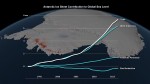
Sunday, June 17th, 2018
Ice losses from Antarctica have tripled since 2012, increasing global sea levels by 0.12 inches (3 millimeters) in that timeframe alone, according to a major new international climate assessment funded by NASA and the European Space Agency (ESA). According to the study, ice losses from Antarctica are causing sea levels to rise faster today than
Friday, June 15th, 2018
Los Angeles, CA –NorthSouth GIS LLC (NSGIS) and Traverse City, Michigan based InfoGeographics, Inc (IGI) have entered into a strategic partnership in the geospatial consulting and systems integration field. Headquartered in Los Angeles, NSGIS has been providing world class enterprise-grade geospatial IT services to the seaport, airport, water and wastewater utility, and local government markets
