
Vaughan, Ontario, CANADA – Teledyne Geospatial, a Teledyne Technologies [NYSE:TDY] company, is pleased to announce that the next generation Optech CZMIL SuperNova topo/bathy lidar system has been awarded both the Geospatial Excellence Award for Technology Innovation and the Geospatial Excellence – Project of the Year Grand Award.
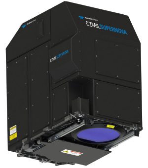
The Optech CZMIL SuperNova boasts the best depth performance and the highest green laser point density in its class. With SmartSpacing technology for even and efficient point spacing, real-time processing capability for reduced post-processing time and configurable modes for maximizing performance in different water environments, the SuperNova provides a wide range of inputs for climate change modelling and is Ideal for inland water environments, base mapping for coastal zones and shoreline.
A true geospatial solution, the CZMIL SuperNova’s workflow is integrated with CARIS Base Editor software for seamless data processing capability and built-in AI techniques for land/water classification.
Teledyne Geospatial Director of Product Management Karen Cove comments, “We are thrilled to have the CZMIL SuperNova recognized by MAPPS and excited to see customers like Dewberry and Terratec tackle challenging projects with its demonstrated efficacy in environments like coastal beaches, inland waterways, coral reefs and deep-water mapping.”
Teledyne Geospatial unifies the hardware and software expertise of both Teledyne CARIS and Teledyne Optech. The new group provides customers with innovative integrated solutions. Offerings include turnkey systems, lidar and sonar integrated workflows and a range of systems and solutions that support holistic, precision data collection.
