DENVER, Colorado – TCarta Marine, a global provider of marine geospatial products, is commercializing a new technique to derive highly accurate shallow-water bathymetry measurements from NASA’s ICESat-2 satellite data. The new methodology is being developed by TCarta with funding from the National Science Foundation (NSF).
In 2018, NSF awarded TCarta a Phase 1 Small Business Innovation Research (SBIR) grant to commercialize new satellite-derived bathymetric (SDB) measurement technologies. Referred to as Project Trident, the research focused on leveraging Artificial Intelligence (AI) – machine learning and computer vision – to determine shallow-water seafloor depth in variable water conditions.

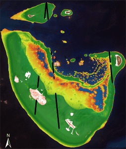
The image shows 10m resolution Satellite Derived Bathymetry produced from Sentinel 2A multispectral satellite with NASA ICESat-2 tracks that were used to inform the SDB algorithm overlaid in black over the bathymetry surface for Thulhaadhoo Island, Baa Atoll, Maldives.
“As participants in NASA’s Applied Users Program, we incorporated laser data from ICESat-2 as a validation tool for the enhanced SDB technologies under development,” said TCarta President Kyle Goodrich. “The results were so impressive we plan to introduce a stand-alone ICESat-2 bathymetric data extraction tool as one of several commercial products from our NSF work.”
NSF awarded TCarta a $750,000 Phase 2 grant in late 2019 to continue Project Trident for an additional two years. Phase 2 will incorporate the new ICESat-2 research into the project’s original objective of enhancing existing SDB technologies with AI capabilities to measure seafloor depths in diverse water conditions.
“The breakthroughs we made with NSF funding will enable us to apply SDB technology in geographic areas and water conditions not previously possible,” said Goodrich. “The results will have commercial impacts on marine operations related to oil & gas exploration and production, coastal infrastructure engineering, environmental monitoring, and geospatial intelligence (GEOINT) activities.”
TCarta pioneered the application of high-resolution optical satellite imagery for seafloor depth measurement in 2014 with commercialization of a proprietary technique. This SDB technology, however, was limited to the relatively calm and clear waters of shallow coastal areas. In 2018, TCarta teamed with jOmegak of San Carlos, Calif., and DigitalGlobe of Maxar Technologies (DigitalGlobe) of Westminster, Colo., on Project Trident.
The Project Trident team added ICESat-2 space-based laser data to the project shortly after the small satellite’s launch in 2018. Developed by NASA and the University of Texas, ICESat-2 (Ice, Cloud & land Elevation Satellite) was designed primarily for polar ice elevation and tree canopy measurements, but the green laser altimeter onboard has proved remarkably accurate at gauging seafloor depths down to 100 feet below the surface.
TCarta is developing a software tool incorporating AI algorithms to automatically extract bathymetric measurements from ICESat-2 data sets. This tool will soon be available for beta testing.
Parties interested in serving as beta testers for the ICESat-2 tool or other Project Trident software components should contact Project Trident Principal Investigator, Kyle Goodrich, at [email protected] or please complete the online Project Trident survey (www.tcarta.com/blog/survey).
About TCarta (www.tcarta.com)
The TCarta product lines includes high-resolution satellite-derived water depth and seafloor map products as well as 90- and 30-meter GIS-ready bathymetric data aggregated from numerous information sources.
About the National Science Foundation’s Small Business Programs: America’s Seed Fund powered by NSF awards $200 million annually to startups and small businesses, transforming scientific discovery into products and services with commercial and societal impact. Startups working across almost all areas of science and technology can receive up to $1.5 million in non-dilutive funds to support research and development (R&D), helping de-risk technology for commercial success. America’s Seed Fund is congressionally mandated through the Small Business Innovation Research (SBIR) program. The NSF is an independent federal agency with a budget of about $8.1 billion that supports fundamental research and education across all fields of science and engineering. To learn more about America’s Seed Fund powered by NSF, visit: https://seedfund.nsf.gov/