Aerial mapping company Bluesky has created a brand new map of Britain showing the health of the nation’s forests, fields and parks. Created using special Colour Infrared (CIR) sensors mounted on an aircraft, the Bluesky map compares the ‘green-ness’ of vegetation thereby providing an indicator of health, vitality and even maturity. With vegetation under threat from pests, disease, pollution and adverse weather conditions the map is set to become an essential tool for those who manage and protect our green infrastructure.
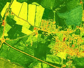 The Normalised Difference Vegetation Index (NDVI), used to create the Bluesky map, is a simple graphical indicator that is used to analyse remote sensed data, such as CIR aerial images, to assess whether the observed target contains live green vegetation. The new Bluesky map is available to view and purchase online at www.blueskymapshop.com
“While we generally see trees, crops and plants as green, in reality the peak reflectance is in the near infrared spectrum, which is invisible to the human eye. Up to 60 per cent of infrared is reflected back to the atmosphere and this is why infrared aerial photography is invaluable in vegetation studies,” commented James Eddy, Technical Director of Leicestershire based Bluesky. “Using CIR vegetated surfaces can easily be separated from non-vegetated surfaces and we can even identify how vigorously plants are growing. The NDVI information can also be used to assist in detecting plant maturity, insect attack or water shortage.”
“We already have CIR for the whole of England and Wales and we’re therefore able to create a benchmark NDVI map. We hope this will become an invaluable tool for monitoring vegetation health. As we are continuously updating this cover with new flying we can also assess how our green infrastructure is responding to the threats of climate, disease and pest attacks,” Eddy concluded.
The Bluesky NDVI map is a companion data layer to the newly launched Bluesky National Tree Map already available to view and purchase online at www.blueskymapshop.com. Bluesky is also investigating the use of other wavelengths and data analysis to provide additional intelligence for tree and vegetation management.
Bluesky is a UK-based specialist in aerial survey including aerial photography, LiDAR and thermal data using the very latest survey technology, including an UltraCam Eagle and an Orion M300 LiDAR system.
An internationally recognised leader with projects extending around the globe, Bluesky is proud to work with prestigious organisations such as Google, the BBC and Government Agencies.
Bluesky has unrivalled expertise in the creation of seamless, digital aerial photography and maintains national “off the shelf” coverage of aerial photography, DTM and DSM through an on-going update programme. By purchasing a world first sensor for the simultaneous capture of LiDAR, Thermal and Aerial Photography data Bluesky is in an enviable position of being able to provide customers with unique and cost effective solutions.
Bluesky is also leading the way in developing innovative solutions for environmental applications including the UK’s first nationwide tree map, solar mapping and citywide ‘heat loss’ maps and is currently developing noise and air quality mapping products. For further information visit www.bluesky-world.com
