On September 10, 2013, what would become a devastating situation, began with an inch of rain falling in Boulder, Colorado. The following day saw another inch, and the rain continued to come down for several more days after that. Only six days later on September 16, some Community Collaborative Rain, Hail, and Snow Network (CoCoRaHS) stations in the area recorded as much as 20 inches or more in total precipitation.
NCDC scientists used the Weather and Climate Toolkit to visualize this historic rainfall event, which preliminary information from Colorado State University suggests was a 1-in-1,000-year event. The visualizations show precipitation estimates from NEXRAD weather radar using Google Earth to provide three-dimensional terrain and map backdrops.
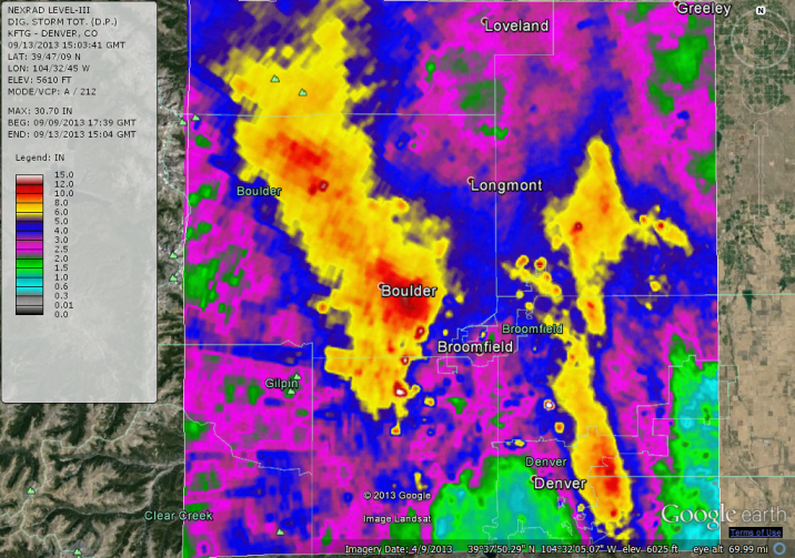
As depicted here, one of the heaviest precipitation areas occurred up-canyon from Boulder near Lyons.
Download an animation of the total storm precipitation as it accumulated between September 10 and September 13 in a 10-second or slower 38-second movie. Or directly launch the Weather and Climate Toolkit to access the storm total precipitation data for the event. A KMZ file for Google Earth users is also available for download.
Due to the mountainous terrain in the area, radar estimates may vary substantially from gauge data. A few small bulls-eye areas of high precipitation may also be the result of ground clutter, which is essentially unwanted echoes in the system due to things like insects, animals, and atmospheric turbulence. The mountains may also cause some “beam blockage,” which prevents the radar beam from seeing around nearby physical obstructions. In this case, the beam blockage may have resulted in some underestimation for the far western areas.
More information on this devastating event is available form Climate.gov in their feature story Historic Rainfall and Floods in Colorado.
