Sensors and Systems
Breaking News
Arup and Ordnance Survey hit major milestone in development of national heat network zoning model
Rating12345 Supporting the Government’s target for heat networks to...
Wingtra achieves a key accuracy milestone with terrestrial laser scanner data comparison
Rating12345Zurich, Switzerland, 12 June 2025—Swiss survey firm Lerch Weber recently conducted...
Esri’s Jack Dangermond Honored with Award from International Fund for China’s Environment
Rating12345 Esri president Jack Dangermond received the 30 Years...

September 27th, 2013
Astrium’s Pleiades Satellite Photographs New Island from Pakistan Quake

  • Rating12345

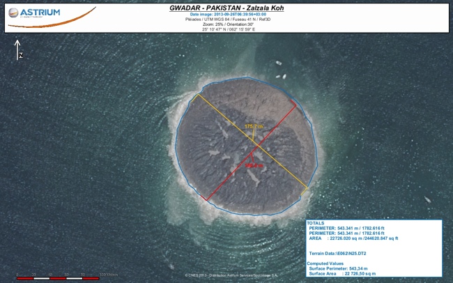
Pleaides the very high resolution satellite manufactured and operated by Astrium, photographed the new island of Zalzala Koh from its orbit 695km above the Earth on 26 September 2013.

Using the satellite image, the geo-information experts from Astrium Services have determined the dimensions of the new island 175.7 metres by 160.9 metres – giving a total surface area of 22,726m².

Zalzala Koh Anglais mesure