Tuesday, February 26th, 2013
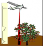
Good management decisions require the availability of quality information. For forest resource managers, the combination of airborne Light Detection And Ranging (lidar) remote sensing data together with Esri’s ArcGIS and the Forest Service, U.S. Department of Agriculture’s own FUSION software have created a powerful 3D environment capable of modeling a forest’s canopy structure.
Thursday, February 24th, 2011
In 2010, an innovative technology began assisting with the assessment of existing forest conditions as well as establishing a viable approach to long-term monitoring to support the management of natural forests in Indonesia. With the ability to rapidly collect highly accurate three-dimensional information of the forest from aircraft flying at three-quarters of a kilometer above
