Tuesday, May 28th, 2013
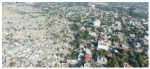
In my work supporting disaster response operations, I have often heard practitioners say, “Where can we quickly get detailed and up-to-date map from?” Chris Hepp, by profession a medical doctor, faced the same issue when deployed on humanitarian and peacekeeping missions with international organizations to Albania, the Kosovo, Rwanda and Haiti. He recognized the value
Sunday, July 4th, 2010
The Winner of the 2010 Buckminster Fuller ChallengeRichard Buckminster Fuller (1895 – 1983), engineer, architect, designer, philosopher and inventor, is prominently known for the famous lightweight and stable geodesic domes he constructed, such as the US Pavilion of the EXPO 1967 in Montreal, now housing the eco-watch centre Biosphère. The domes reflect his continuous efforts
